Hello! My name is Gaia Mulloy. I’m a freshman studying Environmental Science as my major. I’m from a small rural town outside Cleveland, Ohio. My sister, Eva, also went to OWU and so I already knew a bit about the town and professors. I’m a big music nerd, and I’ve always had a passion for the environment ever since I was young. Growing up a bike ride away from a state park certainly influenced my interests
Beginning this course, I had a slight bit of prior knowledge of GIS. My mother’s work involves legal zoning and she uses GIS fairly regularly at her job, so I’ve heard a bit about its potential. Initially, It didn’t occur to me it’s possible utility, especially in the environmental fields. It is incredibly fascinating how much more diverse and useful GIS is as a tool. It’s more than just a mapmaking software, it’s instead used as a way to apply information to maps for computation and analysis.
I didn’t quite understand personally how a lack of “identity” so to speak would ever be a problem. From what the chapter says, it really just seems like it’s an incredibly versatile tool that allows for putting information onto maps and conducting analysis. Another piece of software that came to mind that I think could be compared to this is Blender, which is a 3d modeling program. It’s mostly used for art (3d sculpting, animation, VFX, Motion Capture, etc.), but it has a variety of applications, such as physics simulations or video editing. The reason GIS feels so different, however, is because it’s unique and important uses, analysis and computing, are hidden behind the face of “just another mapping software.” In Blender’s case, the main use (3d modeling for artistic purposes) is the main appeal of the software and it’s fully at the front of advertising. It makes considerably more sense that because it’s best features were hidden, people tended to simply prefer handmade maps.
There is something to be said about “visual intuition” when it comes to analyzing data. Using one’s visual intuition is obviously a step up from text, but additionally, using a program and tool that can accurately map many different factors and display them is likely considerably more useful on a digital map from something like GIS than on other types of maps. Also, having everything in one place where it’s so easily accessible and shareable seems like it was a game changer for anyone who had to work with maps.
As previously stated, my mother uses GIS at her workplace. For her job, it’s more about land ownership. She works in the sale and operation of retail real estate, so things like malls and shops. Having GIS as a tool for zoning and drawing those property lines allows her to clearly see what is and isn’t under certain people’s control. Not only this, but GIS is also a useful tool for seeing certain other information about a piece of real estate. Certain factors that apply to land may make that land more or less valuable and therefore more or less desirable.
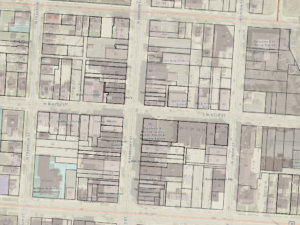
Here’s a web GIS data extract of Delaware county, including information such as property lines and farm lots.
https://gisdata-delco.hub.arcgis.com/apps/delaware-county-gis-data-extract/explore
Here’s a screenshot from this Data extract that shows property lines of commercial buildings on North Sandusky, which is the exact type of work my mother deals with.
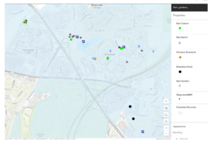
A topic I studied last semester was Green Infrastructure for stormwater management. In order to decipher the locations of things like Rain Gardens or storm sewers, city planners needed to study the land and map out the locations of those items. Here is an example of green infrastructure mapped in an area of Washington DC.
https://owugis.maps.arcgis.com/apps/mapviewer/index.html?layers=b1ae7b7b110447c3b452d9cacffeed36
https://www.sciencedirect.com/science/article/pii/S187802961200309X