- Hello! My name is Alida Askill and I am a freshman at OWU. I plan to major in environmental science and zoology. I am from Seven Mile, OH, which is a very small
 town located in southwest Ohio. I have always been interested in the outdoors and wildlife conservation.
2. Before starting to read the article and look up answers on google, I didn’t really know much about GIS and how it works. It’s cool how one system can have so many different uses throughout the world and spectrum. Companies from starbucks to police officers are using GIS in order to get their job done. All of these different places need the GIS system to turn spatial data into digital data. I had no idea that the GIS system was being developed back in the 1960’s. GIS is both focused on the hardware and software of the technology, so there’s lot of different components coming together to create GIS. A lot of the different diagrams and maps are similar to the ones I used in my stats class last year. There’s a lot of different types of areas of study that use GIS. In simple terms, GIScience answers the how questions, while GISystems answers the what questions. GIS is truly involved in our lives every single step of the way.
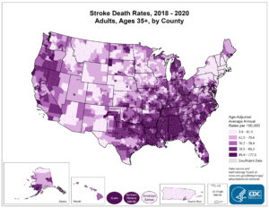
3. Two examples of GIS applications are within the fields of marine biology and public health. Within the field of marine biology, GIS is used to map floor beds, determine ocean currents, manage oil spills, and so much more. People can use GIS for public health by mapping where certain diseases are more common, or mapping emergencies and coordinating between different emergency responders. There is a map below put out by the CDC with help from GIS relating stroke death rates to the area of the USA. This is very helpful to see where many of the stroke patients are to better understand the disease.
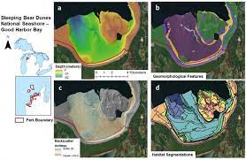
Mapping marine habitats lets scientists study the relation between species and their fellow organisms. Ecosystems can be determined using this system. The map below shows the same area of Sleeping Bear Dunes located in Michigan. The same area is broken up into four different types of mapping, showing depth of water, geomorphological features, habitat segmentation, and backscatter utilities. All four of these different types of maps can be brought together to see how all of these things affect habitats and the animals that live there.
This is a link to a site describing how habitat mapping on marine sea beds are helpful and how they are conducted.
https://www.livingoceansfoundation.org/science/habitat-mapping/