- I am Christopher Nagel (just Chris is fine.) I am in my final semester of senior year and plan to graduate with an ENVS Major/Zoology Minor. Ohio native, from the capital of depression otherwise known as ‘Cleveland’. I have three animals at home, a Russian Tortoise named ‘Shell’, a Saharan Uromastyx ‘Zil’, and a Jersey Wooly ‘Oreo’. In addition to animals, I also find aviation and some maritime history interesting. My biggest hobby is fishing in which I am very avid in.

- Truth be told, I have very little, if any, knowledge of computer software. The only software I have used previously have been RStudio in a few BIO classes and CAD all the way back in Middle School, both with a great deal of difficulty. As to why I decided to join the GIS class, it was due more to the insistence from academic supervisors to take the class and that it would be a good skill set to have in my career than it was my own will and decision to take the class. I have a very loose idea of what GIS is, so I hope to learn more over the course of the class. That being said, the reading does explain it a bit, albeit a bit confusingly. There is no single meaning to GIS given that the applications for it are very extensive and diverse, but boiling it down it seems to be the analysis of spatial patterns using a layered geographical layout. It also appears that GIS has been in use since or before the 1960s, which is interesting as now GIS seems synonymous with computers and programming, but computers didn’t really become a thing until the 1970s, and more so personal computers in the late 70s and early 1980s. Given that, I’m not quite sure how it would’ve been used before then. Using the 1854 London Cholera Outbreak as an example of GIS is something I never would have considered. The famous discovery of the connection between the locations of contaminated water pumps and recorded cases did lead to an overall revolution in terms of sanitation and plumbing, so to see it be in use for so long is interesting. The various modern uses for GIS that Schuurman lists out, ranging from delivery logistics to taxes and the entire power grid, down to each circuit.
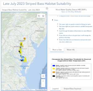
- One application I found for GIS is estimating and mapping the spawning ground, habitat, and migration of Striped Bass on the Atlantic Coast, particularly in Chesapeake Bay. These models are made annually using a variety of data such as the size and quantity of prey, water oxygen levels, bioacoustics, and foraging models. https://www.gsmfc.org/publications/GSMFC%20Number%20043.pdf
- Another application is for use in the aviation industry. Uses range from mapping flight plans, tracking aircraft, and controlling airspace. https://www.esri.com/content/dam/esrisites/sitecore-archive/Files/Pdfs/library/brochures/pdfs/aeronautical-info-management.pdf
-
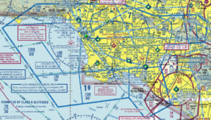
Los Angeles International Airport Airspace