Hello, I am Connor Skidmore from Bellefontaine Ohio. I am an Environmental Studies major and a member of the Cross Country and Track teams.
In Schuurman Ch.1 the author begins by discussing the wide range of modern uses of GIS. They describe GIS as a system used by many but not understood for what it is to the public. The history of GIS seems very confusing because it started as a standard practice done by cartographers that quickly became a digitized field. All around the same time, people from different parts of the world started to make similar systems that today are the foundations of the modern GIS system. The author states that GIS would have been inevitable without interest from Geography but I do not see how that is true because the base field of understanding the information is needed. Even the definition of GIS is very convoluted based on the person and their needs with the system.
This chapter as a whole gave me the ability to understand that GIS is more of a broad net that covers a ton of information rather than one stable thing. GIS is shown in the chapter as a broad and sweeping term that is applied to certain things that by themselves are convoluted. Two people can both use GIS but come up with two very different understandings of the software and its use cases. To me, the history of GIS seems to be a known yet unknown variable based on the chapter because if so many different fields and researchers were doing the same things at the same time how did they finally decide to make the broad sweeping net? This is in my opinion why GIS can have so many different definitions and use cases because the history of it comes from many different people who at the time were doing very different things.
I enjoyed reading this chapter though because it provided a unique into GIS. The chapter also showed how GIS itself is confusing to understand as a whole.
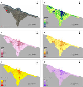
Since I have an interest in City Management I used the keyword City in my search for GIS applications. In my first article, I found that GIS was being used to find if rooftop wind turbines were feasible in Bari, Italy. Since Europe and the Bari have had increasing discussions in “Smart Cities” and energy the study was born to find if rooftop wind turbines were feasible.

In my second article, it discusses how GIS would be used inside of “Smart Cities” which are described as cities that are on the cutting edge of technology and developing new technologies. These cities would use GIS to optimize planning throughout all sectors of the cities while the businesses that innovate in these cities would use GIS to create new technologies.
Sources:
neat apps. lots in city planning and urban management.