Hello everyone!
My name is Graham Steed. Yes, that baby is me (I still wonder what made me so happy; maybe grass, trees, and sustainability, but most likely my mom). Anyways, as I was saying, I am a 2023 senior majoring in Environmental Studies. I am from Marion, Ohio, and I currently live in the Service Engagement and Leadership (SEAL) SLU. I am excited to take this class because I think ArcGIS is an important application that has so many real world uses, so why not learn more about it.
In regards to Nadine Schuurman’s GIS: A Short Introduction, Chapter 1, I found this reading to be both informative and interesting. Although I had previously heard of the debate between GISystems and GIScience, I now understand why making a decision is quite confusing. Personally, I find the theoretical aspects of spatial divisions found in GIScience to be the most fascinating because this is something that historically has been neglected, even in the early days of GISystems. Additionally, in my opinion, I believe GIScience attempts to clarify what the author says is “fuzzy” phenomena, which we have a hard time demarcating, if at all.
Also, Schuurman discusses the technical history of GIS. What I found to be the most intriguing portion of this section was the author’s description of Ian McHarg’s methods for analyzing a particular space. To me, it is interesting that we still utilize McHarg’s “layers” approach in a digital environment. Furthermore, I was surprised that McHarg was able to get the results he was looking for by just using paper shaped into different forms.
Finally, Schuurman explained the different uses among different organizations, such as municipalities, governments, and companies. I think it is awesome that you can map and analyze concrete data like waterways, public transportation systems, bicycle paths, public buildings, et cetera, but also abstract data like religion, income, and race. It is also extremely neat how geographers can utilize GIS data to predict future events like natural disasters.
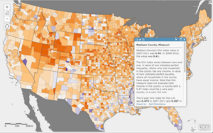
In looking into GIS applications, I researched two topics of interest: food safety and income inequality. I found out that GIS can be used to plot human epidemiology and public health, agriculture, plant and animal health, and environmental factors that can determine overall food quality and safety in a given space, which helps companies and health professionals better protect consumers. In addition, I discovered that you can utilize GIS to plot income levels, which assists a wide range of researchers in answering questions in public health, economics, and government.
Sources:
https://hub.arcgis.com/maps/UrbanObservatory::income-inequality-in-u-s-counties/about
https://www.proquest.com/docview/2741249913?pq-origsite=summon
Baby Graham! You were giggling at whatever props the baby photo guy at JC Penny was waving at you. Yes, there is a whole bunch of cool stuff on mapping?GISing weird stuff (vs. the more basic, easy stuff which is largely the focus of this class). I met McHarg a long time ago. He gave a talk at Penn State. He smoked cigars through the entire talk. He borrowed the tangible layers from cartographers.