Hi everyone! My name is Hannah Cox and I am a Junior environmental science major and zoology minor here at OWU. I am from Orange County, California. Some of my hobbies include lacrosse, reading, and anything related to sea turtles!
Shuurman Ch.1 Thoughts:
When I initially began reading this chapter by Shuurman, it was clear that GIS is a multidimensional software with many different uses for many individuals. That is the beauty (and sometimes faults) of having a program like GIS because it can be used so broadly depending on what it is needed for.
I really appreciated the section discussing spatial analysis, separating it completely from mapping because of the large differences between them. Although spatial analysis and mapping can intersect, spatial analysis generates more knowledge than what can be interpreted from maps or data. The author made it clear that when having GIS, you must understand how to frame questions to implement a successful quantitative model and if it is sufficient in the context of the available data.
I was intrigued by the terms GISystems and GIScience. GISystems contain components like data input, analysis, mapping, etc., whereas GIScience is simply a theory that underlies GISystems. Having each GIS followed by systems or science represented the interrelatedness as well as how fuzzy the distinction can be between them.
I enjoyed reading the last section of the chapter discussing the various ways GIS has been used. It is really amazing how GIS can be used to help various businesses, municipalities, and cities/urban areas. GIS is a fantastic example of how the digital world can help organize and fix real-world problems.
Google/Google Scholar GIS Application:
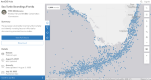
I sought out how GIS can be helpful in sea turtle conservation.
In my search, I found that the Florida Fish and Wildlife Conservation Commission monitoring marine turtle mortality and identifying the mortality factors in Florida since 1980. Between 1980 and 2022, there had been 53,444 strandings consisting of turtles found alive, injured, or deceased. Data was taken around all of Florida with the image showing the bottom south of Florida. GIS can also be used to visually represent nesting data during nesting season along a known nesting beach.
Sources:
https://sjcfl.maps.arcgis.com/apps/Viewer/index.html?appid=1d8d52ed9d5744659daacc32912c3eb1
all cool. turtles.