- A basic introduction to you with a glossy 8.5×11 photograph
I am Savannah Domenech and I’m from the Greater Rochester Area in New York (in particular Webster, NY). I am an Environmental Studies and Geography major. This is my third semester of having Dr. Krygier as a professor in a row. A fun fact about me is I wanted to be a firefighter growing up (and still do have some interest in doing it as a volunteer perhaps one day). I have other fun facts too, like I carried two brand new baby calves this summer; they were heavier than I thought! Below is Caramel, born in the early afternoon of June 28th.

2. Read Schuurman ch. 1 (PDF) & include a few comments, thoughts, etc.
- GIS sure has a lot of uses from Starbucks store planting to epidemiological identification. One use that stood out to me (as I was a farming intern this summer) was using GIS to determine why a certain area of a crop field is not doing well. I also did not realize GIS is used to plan out garbage truck routes
- Overall, the chapter suggests that the two main uses of GIS are making maps and analyzing data
- The article raises the good point that GIS is overshadowing other valid and useful data collection and visualizing methods (like qualitative human geography methods and radar). Honestly, when I thought about radar I thought about how radar could be translated into GIS, not that radar can be its own separate entity
- I also learned that GIS can stand for Geographical Information Science as well as Geographical Information Systems. Systems is more of the final product while Science is the behind the scenes work and algorithms that deeply influences the final product. I really liked what the chapter said: that Systems is “‘where’ spatial entities are or might be” and that Science is “‘how’ we encode spatial entities… and the repercussions of different methods of analysis on answers to geographical questions.” But I agree with the chapter when it says there is a fuzzy boundary between the two
- Before reading this chapter I thought that GIS was primarily for interactive mapping, I did not really consider its other uses
- Something important to keep in mind is that layer overlay is the basis for spatial analysis. In addition, the difference between mapping and spatial analysis is that mapping propositions geographical data in a visual form and does not create more information while spatial analysis extracts information from spatial data. In particular, computers are excellent in solving spatial questions and performing spatial analysis. With this in mind, one thing I am curious about is the delineation between spatial and geographical data
- I did not realize GIS’ origins were so debated and complex
- I think the point the chapter makes about the necessity of understanding the question (and what data is appropriate to that question) you are proposing is essential. If this is not done right the map’s purpose can easily become muddled or the data could be not applicable to the question
- The chapter also rehashed an important concept from GEOG 112: that images (such as maps) have power and that maps allow the data to be visualized in a much better sense than just looking at a huge chart of data (like my South Carolina maps I made in GEOG 112). Furthermore, the chapter points out that while maps help us to see patterns, spatial analysis allows us to be more precise about those patterns
- Also, reemphasized from GEOG 112 is that classification scheme breaks and polygon areas can deeply affect the visual meaning of a map but often most people do not consider why they were chosen and how they correspond to the creator’s interpretation of the data. We need to think about the underlying assumptions that we contribute to our maps, such as symbology, but also consider the underlying assumptions written into the code of GIS
- I also learned through this chapter that GIS can be used to predict future events
3. Use Google and Google Scholar to look into a few GIS application areas: search for “GIS Application” and different keywords, based on your personal interest: wolf telemetry, LGBT, carnivorous plants, hate groups, crime, sewers, crowdsourcing, etc.). Include, in the blog posting, information on two applications with at least one map or image and a source or two.
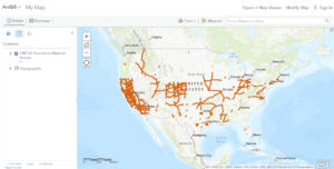
- I searched “GIS application clean water” and found that the EPA has numerous data layers which relate to drinking water mapping applications to protect source waters. One of these layers is the FMCSA Hazardous Material Routes Map.
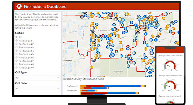
- I mentioned firefighting above so I figured I would also search “GIS application firefighting.” There have been numerous studies relating to the use of GIS applications in firefighting. I also found that ESRI has a whole manual on “GIS Technology and Applications for the Fire Service” from March 2006. Furthermore, ArcGIS offers deployable Solutions for Fire Accreditation Analysis, Fire Hydrant Inspection, Fire Incident Dashboard, Fire Safety Survey, and Fire Service Maps. An example of the Fire Incident Dashboard:
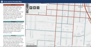
- Finally, I wanted to look into GIS applications for the City of Delaware. One GIS application I found was the City of Delaware’s Snow Priority Map which is important because now students can know why (and also which) roads are and are not cleared quickly.
Excellent post. Garbage trucks AND more importantly, street sweeping routes. Not dissimilar. My dream was to become a street sweeper driver as a child. Elgin Pelican in particular.
GIS is amazing in the fact that it has seeped so far into the management of so many parts of our lives without most people realizing it.