Chapter 3
Chapter 3 focused on ArcGIS Experience builder which allows us all to create a highly customizable web app using the data on GIS. Unlike Web AppBuilder, experience builder allows us to have full control over layout, interactivity and design which lets us combine widgets, maps and text in multiple ways. The chapter talked about responsive design so that apps look good on desktop, mobile and other electronic devices. Some widgets include maps, lists, search tools and charts. You can also connect data sources, create interactive dashboards and apply filters. The chapter also talks us through building simple experiences and also highlights the importance of user experience which is also called UX design and helps with creating effective GIS apps. One useful piece of advice is that experience builder allows us to design conditional visibility for actions and widgets which is similar to how field maps control what fields are being displayed.
Chapter 4
Chapter 4 explores mobile data collection tools in ArcGIS. Survey123 allows us to create smart forms that guide users through surveys with photo attachments, location capture and conditional logic. Field maps is a helpful app for collecting lines, polygons and points in the field including related records and offline collection. QuickCapture helps simplify rapid data collection with large buttons, photo capture and automated location which is ideal for surveys and field inspections. AuGeo is a reality app that visualizes points of interest in real space and offers a unique way to explore data. The chapter mainly talks about conditional visibility, attachments and user input configuration across all these apps.
Application idea
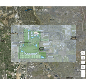
An application idea I have which was inspired by both of the chapters I read was to create a campus trails and parks map showing all the parks and trails near/around Ohio Wesleyan’s campus. This would allow people to explore nearby parks, walking trails and the campus buildings.