Evans Week 2

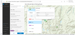
The beginning of chapter 1 sounds like an advertisement. Looks like its written by an Esri employee, so that makes sense. The more I learn about GIS, especially ArcGIS Online, the more I realize how much stuff is made using this software. I really enjoy working in StoryMaps, since its so intuitive. I find the creating expression portion difficult though.

In 1.1, the instructions for adding photos doesn’t match with the wording of ArcGIS Online. Working further, it seems like a lot of the instructions for this don’t match up, so ArcGIS Online has probably updated this stuff since the book was published. I think it helps me stay engaged to have to figure out which tool will do the thing I’m trying to do, since it isn’t too hard to figure out but I do have to think for a moment. I find it interesting that the web maps don’t automatically save, since most apps like this do. Does arcgis online count as an app, or a software? I’m not tech savvy, so I’m not sure exactly what the difference is.

An idea for an application based on Chapter 1&2 is a map and story map exploring parts of the world that I have been, where I recommend going, and places I want to go. I think that would be a pretty easy one. It could be a StoryMap that first goes through places I have gone and recommend going, including pictures and extra information linked in the pop-ups, and then go though places I want to go.

Another idea is something to do with countries that are trying to get their pieces back from museums in other places and who has succeeded in getting reparations and who has not. That one would take a lot more research, but it would probably be more interesting and could be helpful to my art history minor. A swipe block would be an interesting way to show that information, to allow the maps to be compared more easily.

Evans Week 1

I am Claire Evans, a second year Environmental Science major and Art History minor. I took GEOG 291 last quarter.

I created my account for accessing the Community page and found that the link to ArcGIS Blog leads to a 404. The Help page seems like it will be helpful if I forget something basic from the first course and want to re-learn it.

The Notebooks creation seems interesting, though I don’t know any Python so I doubt I’ll use it. I’ve learned that a floor-aware map is a map that shows different levels of a building, such as the polygon of the general building shape and the floor plan inside. I’m interested in architecture, so this seems like a fun tool to play with.

It’s interesting that you must turn off searching only within the organization; it’s useful if you are working with organization specific data but less helpful when learning the program. When I accidentally clicked out of the course, it made me start from the beginning again, so that’s something I’ll have to keep in mind.

Integrating CAD data with ArcGIS seems neat to me because I remember thinking that the CAD integration in GEOG 291 was cool. The Systems Approach to ArcGIS: Architecture Pillars sounds cool too because I like architecture. Python 101 for AcrGIS could be a useful course, since I don’t have any coding experience and it could make me a more competitive job applicant.

Applications of ArcGIS:

Using GIS and Open Web Resources the Reconstruct Great Tang Records of the Western Regions

This paper uses ArcGIS and the biography of Buddhist pilgrim XuanZang to map the locations of many city states and monasteries and uses topographical information to see what routes he likely took between them based on what would require the least amount of climbing mountains or particularly rough terrain.

Generation of a Multi-Scale Historic BIM-GIS with Digital Recording Tools and Geospatial Information

This project used ArcGIS and BIM to 3D model a historic Romanesque town in Italy for UNESCO information and further analysis, since it was difficult to properly model the town using more basic tools due to the large size of the land area and the unusual features of the buildings.