Chapter 7 goes into the basics of how to use 3D GIS and the different applications for this technology. It is mostly used in order to display data in a way that is more easy for people to understand due to it being closer to how things look in the real world. Something that surprised me is that 3D GIS doesn’t appear to be much more difficult to use and make maps with than 2D GIS technology. A common way that 3D GIS is used is to display cities and manmade structures. This is because urban areas can be densely packed with points of interest of differing sizer and shape, and using a 3D map can make it easier to discern these points.
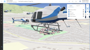
In the tutorials for this chapter, I mostly had a smooth experience with little in the way of setbacks or difficulties. I found it fun to build the park and to see how a space in GIS can really come together with the addition of details provided by the software. I only had one small issue in these tutorials – I ran into a really strange (and kind of funny) bug that added a bunch of different vehicles of different sizes and orientations to the park, including a massive helicopter the size of a small town, a picture of which I have included. I experienced this bug in tutorials 4-6, and I’m not sure if someone edited the websites linked in the book, or if it is some kind of display error. Other than that, I had not trouble in these tutorials and was able to learn a lot about what can be done in creating a 3D scene.