Hello! My name is Trin Fry, a sophomore at OWU studying Environmental Science, Zoology, and Philosophy. I was in the GEOG 291 Desktop GIS course during the first half of this semester, so I feel I have a solid foundation for this course. Looking at the ArcGIS Online home page, it seems that there are a lot of different options for visual creation, including ArcGIS Storymapping, which I have personally used before in a water conservation externship. There are also many other tools, such as help and group features, and tools that allow for the publication of final creations. As expected, ArcGIS is advertised in the “Get Started” section as being a useful tool for mapping and data analysis. However, it also lists data collection and collaboration as features of the site, which I find particularly intriguing, especially that of the field work data collection. It looks like GIS programs continue to expand beyond what I thought of as their primary uses.
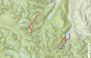
I found the ESRI ArcGIS introduction course very useful. Even though I have knowledge of the ArcGIS desktop software, the uses and data control of the ArcGIS online and desktop versions are quite different. The desktop version, at least on the surface, as we have not gotten deep into the online version yet, is much more complex than the online version. I also like the idea of utilizing three-dimensional or topographic mapping as a form of GIS and can see its uses in many case scenarios. I am excited to explore this programming more and continue to compare it to the teachings of the GEOG 291 course.