Hello, my name is Kathleen, and I am from Dallas, Texas. I am a junior majoring in astrophysics with a minor in environmental science. I plan to work in meteorology or compact object research.
I took the quiz, and I did the ArcGIS online account setup in GEOG 291.
When exploring my account, I found that the help section has a multitude of resources, such as blogs, tutorials, and setup help. Also, the online community is active and has a surprising amount of community types, such as Python and roads and highways.
While reading through the get started pages, I noticed that there are a lot of keyboard shortcuts for Mac when editing map layers. I also learned about floor-aware maps, which can show floor plans and are helpful when looking at optimizing large spaces.
I am glad the training course went so in-depth on the types of sharing. I really enjoyed the activities they provided; they helped me solidify the content from the readings.
The two courses I found most interesting are the field-led data collection and management using ArcGIS course and the ArcGIS field maps migration guide course.
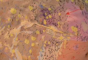
Application 1: Spatial analysis using ArcGIS of the Valles Marineris region of Mars during the 2018 global dust storm
Description: They used ArcGIS to superimpose their data onto a geological map. This shows the distribution of dust with the Valles Marineris terrain.
Link: http://www.jsussenbach.nl/Mars%20en%20ArcGIS_JBAA.pdf
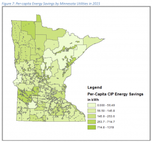
Application 2: Conservation Improvement Program in Minnesota: Addressing an Organization Challenge with ArcGIS Online
Description: This study focuses on creating a story map in ArcGIS online “to benefit Commerce staff by presenting easy-to-understand CIP quantitative and qualitative information for a legislative or general public audience”.
Link: https://conservancy.umn.edu/bitstreams/7ac2d94a-20a3-4255-ab24-c8f978f54e48/download