My name is McKenna. I am a junior exercise science major environmental science minor. I took the first module earlier this semester. I am looking forward to learning more about the online version. My computer is simply too old to handle the online version, so I get the luxury of using desktop computers throughout campus.
I noticed that there is a place where I can add a profile picture and a bio. I feel like that would be overdoing it a bit as I introduced myself moments ago. The Esri Academy is really interesting. It looked like I needed an invitation. Maybe after the course I can look into getting connected and building more knowledge about GIS
It appears that ArcGIS Online is meant to work with a wider variety of people than the ArcGIS Pro that we worked on in the first module. I also noticed that there is an app. It would be cool to use the app later in the semester and connect it to our ArcGIS account. That being said, there was a whole bullet point in the article that talks about connecting the online version to Pro. I had a really hard time connecting to the online version in the first module.
I enjoyed taking the class. It didn’t quite take me the whole two hours that I allotted for which is a relief. I thought it was really cool how we could create instant apps that make it a lot easier to share with someone. It’s a smart tool that someone created to make sure that they could pass information quickly. I thought the course itself was intuitive and easy to follow along with. I haven’t carefully read the entire syllabus, but I hope we do another training module or two before the semester is over.
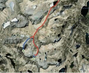
I looked at nursing home evacuations versus shelter in place during hurricanes. I looked at this specifically by looking for a connection between ArcOnline and physical therapy. The researchers found that this was really the first study of its kind. They proposed continued use of GIS to establish a protocol to ensure that the most vulnerable are safe
Sakib, N., Hyer, K., Dobbs, D. et al. A GIS enhanced data analytics approach for predicting nursing home hurricane evacuation response. Health Inf Sci Syst 10, 28 (2022). https://doi.org/10.1007/s13755-022-00190-y

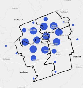
This second map depicts clustered sport delivery points in the five City of London Ontario planning districts. It is mapping the different hot spots of organized sports. Organized sports are a clear indication of an active individual. I looked specifically for youth sports but I think the online version might not have the layers. This paper did organized sporting events overall.