Update 6/6/2022
First: round of introductions: where from, major (or maybe major), something fascinating about you that will make us never forget you
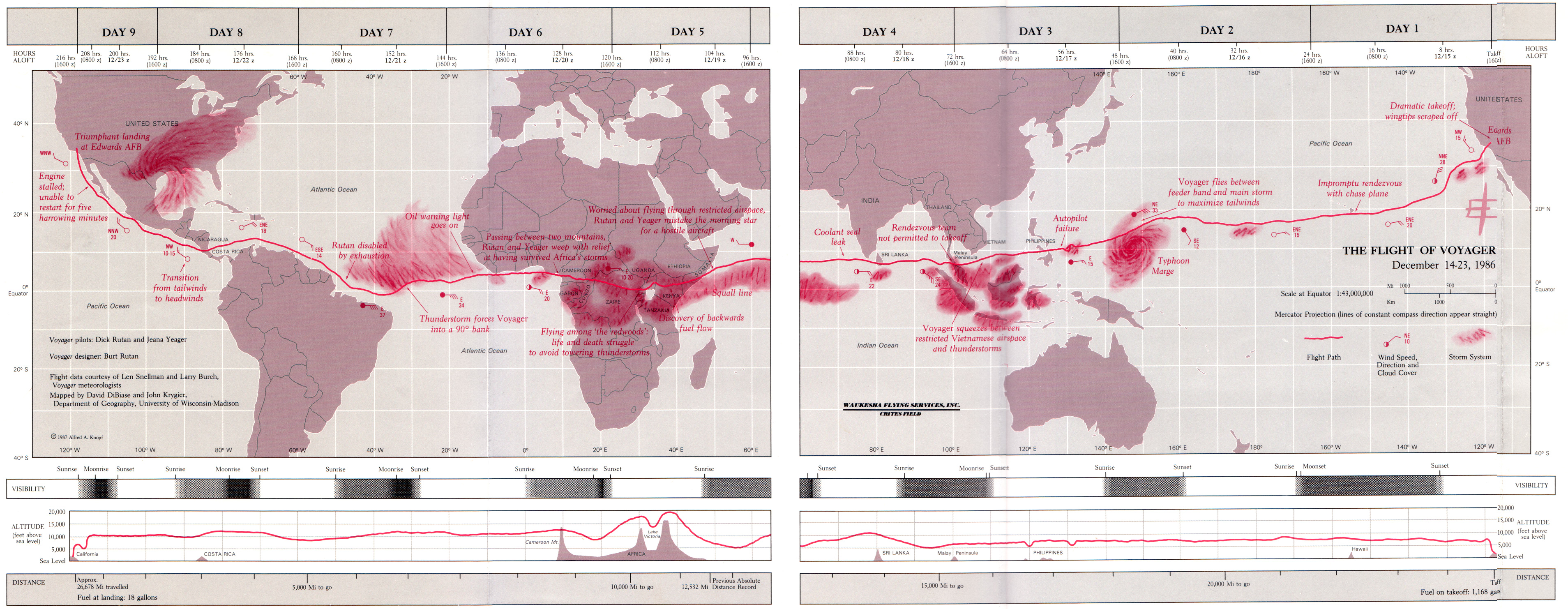
Second: Handout: 1987 Voyager Map (right mouse click to open up a big old scan of the map below)
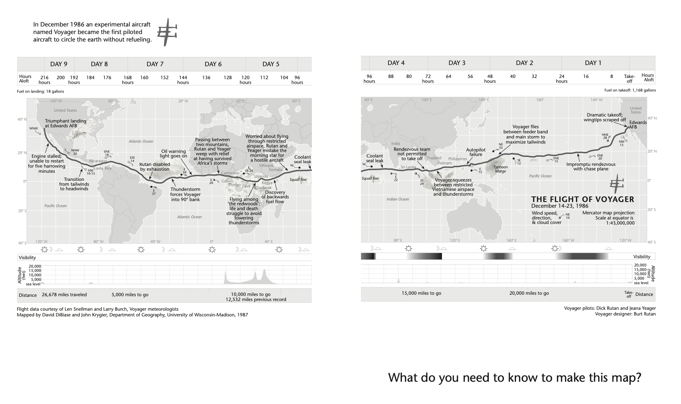
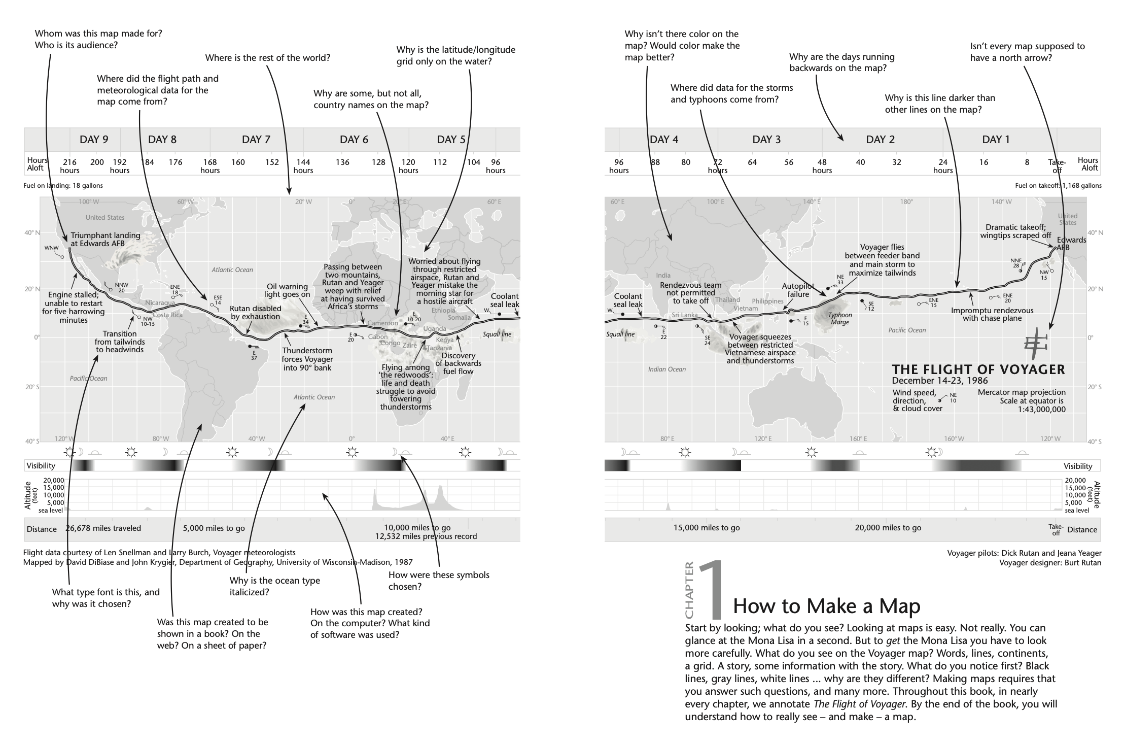
The “new” Voyager map, redesigned for the Making Maps book:
This Course
- Technological competence: you are functional with a diversity of technologies, software, moving data from one form to another, and learning how to solve problems.
- Methodological competence: Given an understanding of the technologies, you understand the process for addressing questions and generating understanding in ES and Geography
- Mapping competence: Understand and be able to use guidelines for creating effective maps and using GIS to effectively communicate and understand.
- Critical competence: Understand mapping (and all geospatial technologies) as powerful and complex (eg., propositions rather than representations), and open to a range of insights from perspectives such as feminism and indigenous theory.
One project using ArcGIS Desktop and ArcGIS Online and other related software
- Focus on mapping historical population data for state/states; find data on web
- Learn blogs (WordPress), HTML scripting, and Map Mashups (Google Maps)
- Process census data (Excel, to DBF or .xls file)
- Learn basics of ArcGIS (Pro) and ArcGIS Online
- ArcGIS Desktop: link data to map, generate population change data in ArcGIS Desktop
- Mid-project evaluation
- Data classification and symbolization in ArcGIS Desktop
- Transfer ArcGIS Desktop layers to ArcGIS online
- In ArcGIS Online, create a basic interactive app. Embed in the HTML code created in (2) above; end up with a personal website linked to lab blog, mashup, embedded animation from ArcGIS Online.
- Final project evaluation
Woven into this are four “Deep Map Thoughts” discussion sessions with associated readings/activities. You will review the material before our discussion, create a one-page document with notes, comments, questions, etc., and participate in a discussion of broader, critical issues related to maps and mapping.
Sharing Work with Instructor
For most of the labs, I’ll check that you have your work done by looking at the finished stuff in class (say, in ArcGIS) or on your blog (the write-up for the labs). It’s your responsibility to make sure I take a look at your stuff in class on the due date. In a few cases, such as the mid-project and final project evaluations, this is how you turn stuff into me:
- Go to your OWU Drive account
- Create a new folder with the course and your last name
- +New button (upper left) >> then Folder
- Larry “Bud” Melman’s folder would be: GEOG 112 Melman
- Share that folder with me (so I can edit)
When you are ready to turn in your work:
- put the document in the shared folder
- email me that your document is in the shared folder and ready for me to review
The GIS Lab (207 SCSC)
- Door open hours: 7 am-7 pm M-F
- other hours: get 207 door lock code from instructor & use OWU ID card to get in the building
Basic rules and regulations in the Lab
- The Lab is for students in Geog and ENVS courses and Department majors/minors
- Students in 112 will need to work on a specific computer; please be diplomatic if you need to ask someone (not in the class) to move to a different computer when you are working outside of class times (students in 112 have dibs on a computer)
- Log in using the info on the monitor base (not your own account!)
- Printing is free! Let Krygier or Rowley know if the printer is not working
- The Lab has no full-time attendant or technical staff: let Krygier or Rowley know if there is a technical problem, and put a note on the computer indicating the problem.
- Don’t modify, add, or remove software: ask if you have software questions
- Projects will typically be discarded at end of semester (back up your work)
- Food and drink policy: don’t make a mess
- Relatively open and unrestrictive: don’t do things that make us impose rules
Before next meeting:
DMT I:
- Read (for discussion M) KW up through Ch. 1 & 321 Definitions & Ce n’est pas le monde & Right Map Making (all here). For W read KW Ch. 2 (What’s Your Map For?)
Monday, Aug. 29: DMT I: What is a Map? KW up through Ch. 1 & 321 Definitions & Ce n’est pas le monde & Right Map Making (all here)
Due: DMT I: Shared document with notes, comments, questions on DMT I readings
Also:
Choose a state or states you are interested in and why
Review the Syllabus and the Course Schedule
- Send me an email (jbkrygier@owu.edu) from your OWU email account and include the following information:
- Your Name (preferred name)
- This course (Geog 112)
- Major (if known)
- Year at OWU
- Hometown (and state or country)
- Computer Experience
- Other ENVS or GEOG courses you have taken or are taking (name or number)
- Reason for taking this course