week 5

Chapter 7 was all about understanding the basic terminology of web scenes they give us opportunity to create web scenes using the same viewer. It was understanding the value and configuring 3-D maps. The two types of 3-D scenes we learned about were photorealistic and cartographic. The photo realistic were used to create features and cartographic used to do thematic mapping to display features. I learned as there is a lot of ways to represent 3-D images and data.

I think i will be creating a app off of the information from chapter 7 for my second app.

smith week 4

Chapter 6, demonstrates how screens can be used in real time. Chapter 6 divided spatiotemporal data Into four main types: change, stationary fixed, and moving each give you the ability to view different patterns and trends. I thought it was very interesting and will be extremely useful for the real-time data to be broadcasted to agencies like emergency response or environmentals or just companies that need real time feedback


smith week 3

Chapter 3 was all about additions of the experienced builder it contained widgets, i.e. basic widgets, their functional layout, and how they perform as Apple tools and layout widgets all the way up to target and triggers I think the widgets are good way to make a more interactive map from how we did in 291

Chapter 4 focuses more on mobile GIS, i.e., the mobility of itsmation accessing a large volume  real-time info of users. It was built around mobile devices operating mobile systems and wireless communication. I think that I would like to use the surveys for my final project since we don’t have a library anymore, and that was my favorite place to study. I would like to find out where other students study.


smith Week 2

Chapter 1 and two of the web GIS book introduced the basic and benefits of web GIS this combined web technologies with geographic information systems. The systems were global access, cost effectiveness, cross platform compatibility, and most appealing to me ease of use web GIS revolutionized spatial data analysis to where it is now used in just about every facet of life i.e. government industry, science and daily life chapter 1 focused on the key elements like user group and content it also emphasized how web GIS data sharing can make analysis easy it introduced five core GIS components data layers tools, online maps apps, which enable dynamic spatial applications. I was familiar with some of the stuff from taking 291

Chapter 2 discussed layer types in the ESRI geospatial cloud. These features were features tile scene and picture layers, and it showed how these layers could be used to create high-quality maps. I also found it interesting how arc GIS arcade allows the tailoring of layers and pop up appearances and how the capabilities enable users to interpret data better.


Smith Week 1

Hi everyone. My name is Owen. I’m a senior here at Ohio Wesleyan University I’m a zoology major. In the beginning half of the semester, I took GEOG 291, so now I’m finishing the semester off with GEOG 292.I learned a lot and 291. It was very informative class. I felt like i took a lot away from it so I’m excited to learn more in 292

Having taken 291 my mind was already blown with the sheer vast capabilities of arcGIS as a program. And after looking around the website and scrolling through the settings, I can say that I am less overwhelmed at the start of this arcGIS online then I was at the start of 291.

The introduction on arcGIS was straightforward and left me with little to no questions. I found the ability to make maps off-line to be extremely interesting, especially compared to 291 which I had to do on a desktop working with arcGIS online. Makes this class and this is fieldwork much more helpful.

When tasked to google and find arc online, I chose something that I enjoy doing on my weekends here at a Ohio Wesleyan University that being hiking. So I googled arc online mountain trails. And began searching. I found one that described geospatial tool development for the management of hiking trails specifically in the holy side of meteora this was interesting to me because last semester I used the tools in 291 to make the maps and now I’m seeing them coincide with something I’m interested in and AR online

TqsTX4-ArcGIS Online Basics_Certificate_03222025

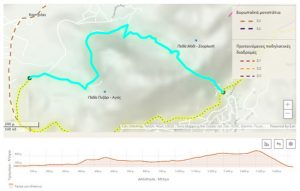
Potsiou, Chryssy, et al. “Geospatial tool development for the management of historical hiking trails—the case of the holy site of Meteora.” Land 12.8 (2023): 1530.