Shaw Final

App 1:

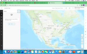
This app is designed to show people every hiking, walking, and biking trail in the state of New Jersey and also shows where all the black bear management zones are in the state. The idea of this app came from another app called all trails that shows users of the apps where trials are in the areas they are searching for. This app does not require users to report trails which most apps like this require. The app takes all its information from the parks department of New Jersey and their information of bears from the New Jersey environmental protection agency. This app will hopefully convince people that may not explore certain areas of the state like the Warren county areas because of its secluded areas to get out and explore without the fear of encountering a bear which is the most frightening animal you will come across. The trails would also be able to be live tracked which would allow people to track how far they have walked, ran, or biked while calculating elevation gain and other things that can be tracked. The app will be called NJ Trails.

App 2:

This app is designed to show where open job applications are in distance from the subway stations and lines in New York city. This will help people who work in the food industry and are trying to find a job or possibly look for a different job and want to know about their commute in the city. New York City is one of the most densely populated cities in the country with over 23,000 restaurants in the city and over 250,000 thousand residents that work in the city. There are constantly new ones popping up every day and restaurants closing every week. It is almost impossible for a simple line cook to figure out where to work next without putting hours of their own research into finding a new place of work. This application takes that stress and hours of work away and simply shows you when a new place is open to work with the simple click of a button. People are able to look at an opening and place their home on the map and see how long the commute would be. Restaurants would just have to post their job opening on the map and people who have the app will be able to get the alert that there is a new opening and see if it is a good fit for them to work there. This will help the businesses find workers faster and help residents who are in the job market find a place faster. The app will be called food 4 hire NYC.


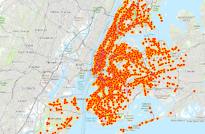
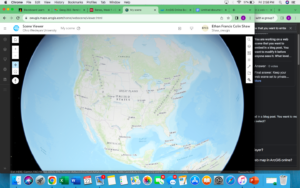
(I could not figure out how to share it with the class so here are screenshots of them and they are public on Arc online)

Shaw Week 6

Chapter 7

The tutorial for this chapter allows you to learn how to create web scenes and 3D web apps. I did not have many issues doing this tutorial as it was very easy to follow and it was not as long as the ones in the past. In ArcGIS, 3D web maps are referred to as web scenes also known as 3D scenes. By using 3D it allows you to bring an extra dimension to 2D maps which often brings advantages in data visualization, analysis, and communication. In today’s world 3D GIS is a crucial component for research frontiers and hot spots which include digital cities. A web scene can also have multiple layers which include feature layers, map image layers, raster tile layers. Scenes have four main types of elements: Surface, features, textures, and atmospheric effects. Finding other applications of 3D maps would definitely be useful and interesting to learn.  An idea I have is to use a 3D model of Delaware and tie it to multi unit houses in the city and see how that affects the population density of certain parts of town.

Shaw Week 5

This chapter was a lot easier to follow from the ones from last week, it helped a lot more that we only had to focus on one chapter this week. The chapter started on how to create a dashboard which helps for displaying information. The dashboard also is extremely helpful because the information is constantly changing and the dashboard application constantly updates with the changes. I am not entirely sure what else the dashboard would be helpful for besides updates because the book does not discuss in a lot of detail.  I did like looking at the different tools and how they can be used for collecting data. This section also showed me new parts of ArcGIS online and how you can put multiple things on a page to display. This chapter also focused on stream layers and how ArcGIS online uses them to look at data and sort it. Looking at the real time traffic cameras were very cool. I am not really sure how I would make an application based on what this chapter taught. An idea that might work would be to use a time application in something like seeing the population of wildlife through the different seasons. This application could help with migration along with just seeing what kind of presence these animals have during different times of the year in different areas.

Shaw Week 4

Chapter 3:

  • This chapter was a lot easier to follow because it only focused on one topic.
  • The tutorial was a bit confusing because I could not find the 3D map that was required to use in the tutorial so mine did not turn out as it should have.
  • The 3D maps look very interesting and I am looking forward to learning more.


Tutorial

  • It does seem more difficult to do these tutorials on my personal computer than in the GIS lab. I assume it’s because my computer can not hold all the data I need. 
  • These tutorials are much longer than the ones in the last class so attention to detail is very important when doing these.
  • I also can not find the button to switch it to 2D and 3D.
  • I completed the tutorial but did have some difficulty due to missing some key pieces like the 3D map.


Chapter 4: 

  • Using Web GIS on your phone is very interesting, I am not sure how people can use it on their phones efficiently as there are so many parties to making these maps.
  • Having WebGIS being mobile does open up a lot of doors for people that need maybe a very specific location. Having your phone being able to access the data will help with GPS and location specific issues. 


Tutorial:

  • I had many challenges with this tutorial and after reading other peoples posts it seems like it was a common trend. 
  • The instructions were very confusing and I could not follow or find everything that was being asked. 

Shaw week 3

Chapter 1:

  • Web GIS is the combination of the web and geographic information systems.
  • The first operational GIS was developed in the 1960’s by Roger Tomlinson.
  • Web GIS is used within the government, business and science world, and even in people’s daily lives.
  • ArcGIS online is a software offering web GIS, ArcGIS.
    • With the benefits and easy to use software ArcGis online has been picked up by many governments and commercial organizations around the country. 
    • ArcGis enterprise is a web gis software product that organizations can use.
  • ArcGis online has four software components: Portal for ArcGis, ArcGis server, ArcGis data, and ArcGis web adapter. 
  • In chapter 1 the first tutorial shows you how to create a Web GIS app that introduces the points of interest (POIs) on maps.

Chapter 2:

  • Smart mapping and storytelling with GIS
  • Feature layers: the most common type of operational layers
    • Web layers are essentially web services that can be reused in many web maps, scenes, and apps.
  • This chapter mainly focused on hosted feature layers, which are the most widely used operational layers.
  • Smart mapping enables users to visually analyze, create, and share professional-quality maps.
  • Tutorial 2 will show you how to create a Web GIS app that presents the spatial patterns of populations. 


Geog 291 application:

I used the applications from chapter 1 and 2 to help me show the population in Delaware county as well as the population that was above a certain age.

Shaw Week 1

I am Ethan Shaw, a senior from Woodland Park, New Jersey. I took the GIS 291 class last
semester so I am a bit familiar with GIS and how to operate it. I enjoyed the course's last module
and am excited to see what this one has in store.

Poking around comments:
I looked around at my profile and my esri. I am not sure what to add to my profile, I
already used it for the last class.
When accessing my ESRI I am not sure what I am looking for, it says I need to put a
code in so I will have to email the professor to navigate that.
Reading:
The reading was very easy to follow and was quite interesting when explaining how the
application is used. ArcGis online is very adamant about sharing work and collaborating as a big
part of the application. The application can also present data and maps to any group of people
and make it easy for them to understand.
Training:
The training was very easy to follow and was fun to do. The quizzes were not hard and helped
me learn a lot.