Skidmore Final

Chapters 1-4 Application:

I built an app that allows viewers to select the residential halls throughout campus. While this app is very basic and rough at the edges it could be cleaned up with a little time (which I do not have) but I think this perfectly shows how a story app can be used. Visit the app at this link

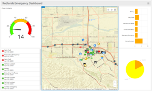
Chapters 5-8 Application:

In this scenario, I built a survey very similar (basically the same but with a few minor tweaks that made it easier to work with) to the campus 311 survey. This survey allowed me to make a fake pool of data that could be used in a situation to be used for a better reporting system for ABM, Public Safety, and BnG. Then made a map with the sample data (I could not get the live map to work properly with the dashboard so I just made a non-updating map with the sample data. So this could be enhanced and potentially used to better visual reports given to each of the campus authorities for a better understanding of each of these reports

Dashboard

Sample Map

Live Map

Skidmore Week 5

Chapter 6:

I personally really enjoyed this chapter and how everything was put together. I found everything done had a purpose and could be used in other scenarios, which I found really helpful. Also, the last example seemed a little out of place within the chapter compared to the instance with the dashboard. This was one of the easier chapters as a whole though

.

Skidmore Week 4

Chapter 3

I have never been so frustrated with GIS before. I tried so many ways to get the program to work but nothing was working and I was unable to get the Web AppDeveloper to work at all which is disappointing. So I just read through everything and all the steps made sense and I feel the apps are way more powerful than just a map. Hopefully, this doesn’t put me at a disadvantage later but I could not handle trying to get it to work again.

Chapter 4

I really enjoyed this chapter and the tutorial throughout the whole thing. I am really getting annoyed installing things but it gives good programs and how they can be integrated into systems as a whole. I think my favorite part was creating a map to use for data analysis of a survey. I found that this can be applied to many different scenarios or potential situations that could be applied to this kind of data collection. Also being able to map that kind of data gives you access to further tools to be successful with that information.

Skidmore Week 3

Chapter 1

The chapter discusses general use cases and an understanding of how to use Web GIS. For me, this was the first time making an app inside of Web GIS which I found personally interesting.

Chapter 2

The chapter discusses generally how to tell a story using Web GIS, in this scenario, it was showing how population trends have been changing since 2010-2016 to tell the story of the US Population

App Example

The scenario in Chapter 1 is a good use case of Delaware Data to create an interactive map throughout campus with pictures and details.

Skidmore Week 1

Hello!
I am Connor Skidmore a first-year student majoring in Environmental Studies and focusing on ESG work and Environmental Consulting.

ArcGIS Online
ArcGIS Online is used generally in tandem with ArcGIS Pro usually in the field where a computer that can run ArcGIS Pro is unavailable. So they will use ArcGIS Online to create a map and then later use Pro to analyze the map created.

ArcGIS Online Basics
I learned about Apps and how they can be used instead of maps or scenes.

Uses of ArcGIS Online
Natural disasters, risk salience, and corporate ESG disclosure (ArcGIS Online ESG)
In this example, ArcGIS was used to find the approximate distance from the headquarters of these institutions in relation to disasters and they found the ESG disclosures became more consistent with disasters.

Interactive Geoinformation Three-Dimensional Model of a Landscape Park Using Geoinformatics Tools (ArcGIS Online Park Management)
In this example, ArcGIS was used to create a map that will better allow park management to better utilize the land inside of the park and further understands the barriers within the park.