App 1: 3D Storymap on Locations to Visit in Seattle
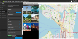
This is a quick storymap showing off some of the best places to tour the city. I researched and found the coordinates for each location in Seattle that I wanted to show off, I compiled them in a spreadsheet and imported it into ArcGIS Online, where I made slides that I put into the storymap you see before you. I decided to use OpenStreetMap as the basemap because I think it was the most aesthetically pleasing 3D representation of the area. I also adjusted the time and made each point have a large 3D Cone icon.
https://arcg.is/0C8vvz0

App 2: ANOTHER 3d Storymap on Locations to Visit, this time surrounding Seattle
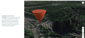
I love going on hikes and the nature around the Emerald City is in a league of its own so I decided it warranted its own storymap. I followed a similar process to making my Seattle storymap, but I used an imagery basemap to provide a realistic aerial view of the terrain and chose trailheads around the area as the focal points. I carefully selected some of the best hiking spots that offer breathtaking views, unique ecosystems, and memorable experiences. Additionally, I used the sidecar feature in the ArcGIS Online StoryMap builder, which allowed me to incorporate smooth transitions between each point of interest.
https://arcg.is/1q8nHT
