Hi, I’m Akiilah Whitfield, I’m a first-year Environmental Science and Zoology double major, double minoring in Geography and Environmental studies. I have already done GIS 291 and it was a little frustrating, but it’s really cool to be learning these skills and it broadened my love for Geography. In this class I hope to stay more on top of my work so that I’m not constantly rushing to complete my tasks every week.
ArcGIS online organization:
Online sharing of maps and data is facilitated through different members and can be customized to fit needs. There are different content types (layers, maps, scenes, apps, files).
I relearned basics about maps and all of the different functions that are in use both is the ArcGIS database, and also online.
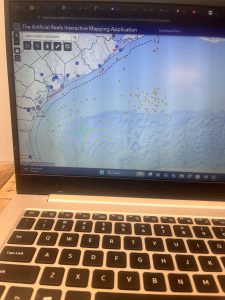
Map showing data for artificial reefs in a certain plot of water in Texas. This is an interactive map application that is open to the public for viewing and understanding.
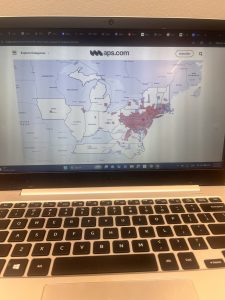
This map shows the flow of spotted lanternfly spreading across the United States. The person who created this map included animations of lanternflies when you first open the map, alluding to the idea that they aren’t great insects. The map shows that the bugs are spreading across 14 states and counting with every state excluding North Dakota being susceptible to the infestation (due to extremely cold winter conditions)