Chapter 7
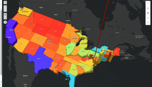
In this tutorial, I learned how to create web scenes and 3D web apps using ArcGIS, transforming maps into more immersive and interactive experiences. It was fascinating to see flat 2D maps evolve into 3D maps that tell a visual story. In Section 7.1, I started by exploring the Scene Viewer through the StoryMaps app, checking out various types of scene layers. Next, in Section 7.2, I created a thematic web scene to visualize the population and population density of the United States in 3D. By applying extrusion based on each state’s population, the flat map turned into a three-dimensional landscape that clearly showed differences in population density, from sparsely populated areas to high-density regions like Washington, D.C.
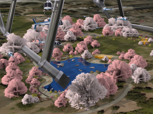
In Section 7.3, I tried designing a 3D park scene using realistic 3D symbols like trees, benches, flowers, cars, and boats. However, nothing appeared on the map, and I soon realized that the original park data was missing… In Section 7.4, I used elevation data to visualize features not only on the ground but also underground and in the air, including tunnels and helicopters. There was even one enormous helicopter that really stood out. Finally, in Section 7.5, I learned that even small edits to 2D data can dramatically enhance the expressiveness of a 3D scene.