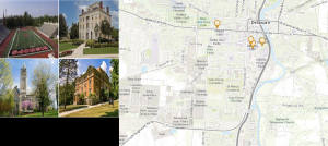
For the first part of my final, I created an Attachment Viewer app featuring four historical locations at Ohio Wesleyan University. The project included four attribute fields: the building’s name, a brief description of its historical significance, and its latitude and longitude coordinates. The descriptions were sourced from the official Ohio Wesleyan website. I successfully mapped each point and used the Instant App tool to display them. Overall, the result is a simplified version of the interactive map available on the university’s website. I couldn’t get the link to work so I have provided screenshots below.
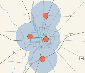
For the second part of my final. This app identifies potential emergency shelter sites across Delaware County, Ohio, and evaluates their accessibility based on proximity to population centers and major roads. It integrates spatial data management, geoprocessing, and digitizing/editing techniques from Chapters 5–7. The final result is an interactive map that helps planners and emergency responders evaluate shelter distribution and identify coverage gaps. The app allows users to click on each shelter and view its attributes, including distance to roads and capacity details. Again I couldn’t get the link to work so I have provided screenshots below.