My name is McKenna Downing, and I am a Zoology major/ENVS minor graduating this MAY! I am on the track and cross country teams as well. I have taken the first module of this course (GEOG 291), and found it enjoyable, so I am excited for this module too. I have completed GEOG 291, and therefore I’ve completed the reading of the course blog and activating my WordPress account. I have also completed the quiz and the necessary actions for this week!
One thing I noticed about the ArcGIS Online website was that there are examples of maps from previous years, including data about trees, wifi, censuses, and floods. I think that’ll be helpful in the future. Another thing I noticed was that the website as a whole should be easy to navigate. It already seems to be a lot less tedious and confusing than GEOG 291 was!
I read through the different sections of Get Started: What is ArcGIS Online and found some cool stuff! The first main thing I went through was the “Work with maps” section, as I thought that would be the most helpful. I found that it seems to be similar to the ArcGIS Pro from GEOG 291, especially with the Settings and the Content panes on either side of the map. I also found that there are keyboard shortcuts which are neat! The second thing I found helpful was the “Work with content and data” section; which again I thought would be the most useful. I found that I can manipulate data to make it visible to others, which is something we could not do in GEOG 291. This would be super helpful if I were to need help or advice on a project!
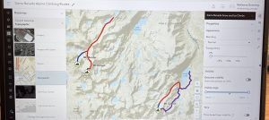
While completing the training for this course, I was able to notice two things that were the most helpful. The first thing was how to change the controls to edit who can view your work and data; which could be anything from private, group, organization, or public. I thought that was neat. The second thing I found helpful were the activities to do the maps. The one I screenshotted was thorough and answered any questions I had about it. The website seems user friendly and easy to navigate, and I was able to learn more from the training. I attached a screenshot of the map below. I could not get my certificate to show up, so I screenshotted the part of the website that said “Completed”.
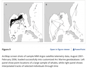
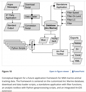
- “A Customization of the Arc Marine Data Model to Support Whale Tracking via Satellite Telemetry” – this involved changing the code of the ArcOnline system in order to track marine mammals, and the authors focused on whales. The model that they are creating is called Arc Marine, and when trackers were placed on whales, they were able to track the whales’ movement across the ocean, and know how to edit the format of the website to accommodate that. I have two screenshots for this paper.
- Lord-Castillo, B.K., Mate, B.R., Wright, D.J. and Follett, T. (2009), A Customization of the Arc Marine Data Model to Support Whale Tracking via Satellite Telemetry. Transactions in GIS, 13: 63-83. https://doi.org/10.1111/j.1467-9671.2009.01159.x
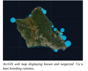
- “Using ArcGIS as a Conservation Tool for Wedge-tailed Shearwaters (Ardenna pacifica) on O‘ahu, Hawai‘i” – this study involved using ArcOnline to create a web map of the breeding grounds of the wedge-tailed shearwater on the island of O’ahu. The authors created a public map using the website and used it for educational purposes, as the shearwaters have seen a decrease in their population. I have one screenshot for this paper.
- Written by: Jennifer Urmston, M.S., Hawai‘i Pacific. Universityhttps://hiaudubon.org/wp-content/uploads/2021/12/Elepaio81.5.pdf