Chapter 1:
- One method to create a new feature layer is by importing it into ArcGIS Online
- In your map, you have the options to add layers and tables, change the basemap used, as well as create legends and charts that correspond to your map
- You can also search for and import layers from the ArcGIS database, as well as from living atlas, with the option to change visual characteristics such as transparency, layer style and symbology
- You can share the maps with others within your organization, or publish the map so that anyone can access it.
- You can create story maps that guide the user through your map, with images, videos and other media, similar to a presentation but spatially.
Chapter 2:
- ArcGIS Online has a large variety of templates available, each suitable for different projects such as 3D scenes or collecting and categorizing data.
- Each WebGIS app is formed from 3 components, the basemap, the operational layers and the additional tools specific to that project.
- Living Atlas is an Esri hosted collection of maps, databases and apps that are available for you to add and use within your own apps and maps
- Arcade lets you use expressions to manipulate data that you already have, instead of needing to change the underlying data
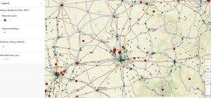
One idea I had for a potential application use would be mapping rail lines within Ohio, and cross referencing them with major industry locations, such as steel mills and coal mines.
Below is my attempt at making a map similar to that idea, which has Ohio’s rail lines, as well as markers delineating historical locations throughout the state (Both Layers I found in Living Atlas)