My name is Gabrielle Mulloy, I’m an Environmental Science and Geography major.
I have taken GEOG 291 and other classes requiring GIS, so I am aware of the basics of what GIS is as well as using Web GIS.
GIS is a tool used to analyze and compute 2d and 3d spatial data. ArcOnline is an entirely online counterpart to ArcGIS Pro. Being online, it’s made much easier to share and publish data and work, with a heavy emphasis on creating web pages and interactable maps, scenes, and apps.
The interactive and sharing aspect of WebGIS seem to be the main appeal of this software rather than analysis like in ArcGIS Pro. It’s very intuitive and simple to make interactive elements. I can see how this can be used to easily create pages that can tell stories or show information in a really unique and valuable way. Sharing spatial information is a really difficult hurdle to overcome in geography, and the way ESRI designed this is genuinely really impressive.


One of the courses I’m interested in is ArcGIS Online: Performing Analysis. I’m interested to see how analysis differs between ArcGIS pro and online, and I assume Online’s analysis is much quicker and simpler. ArcGIS Pro is very complex and not very user friendly, so I wonder how much time I could save by becoming familiar with ArcOnline analysis.
I’m also interested in the ArcGIS Experience Builder series. I always find it hard to explain geography to others, and so to be able to just write a website that conveys my point with interactive elements and maps would allow me to share so much more information. I’m very passionate about scientific communication, plus I think it would be a great job skill to know how to share scientific information using these tools.
I am well aware of GIS applications, but I found a new one using online GIS.
Theobald, R., Palmer, A., & van de Gevel, S. (2019). Interactive Mapping for Transparent Redistricting. Research in Geographic Education, 21(2), 11-38.
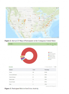
This article is first and foremost about how important geography is in politics, specifically in voting. This article is about how to inform the public about politics and gerrymandering using geospatial information systems. They asked survey participants to do an exercise in GIS to familiarize themselves with geography. While not strictly about Arc Online, it’s very obvious how this article could use Arc Online to tell stories and inform people about geographic and political history.
