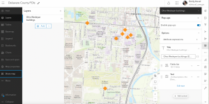
App 1:
For my first app, I created a web map showing academic buildings in Ohio Wesleyan University. This comes from ideas in chapter one. I first went on google sheets and made a list of buildings, a small description of what the building was, and the location in latitude and longitude. Then I downloaded a csv file and uploaded it to ArcGIS online, changed the basemap and the symbol for the buildings, and configured popups. I shaved the map. The next part I wanted to create a web app that is mobile friendly. I clicked creat app, then instant apps. I chose the basic app for this. Then I published the app.

https://owugis.maps.arcgis.com/apps/instant/basic/index.html?appid=243489a21d4d4971887e181e9891730d
For my second applicaiton, I wanted to create a survey using ArcGIS Survery123 on where students on Ohio Wesleyans campus like to eat. I made it so it can work on phone as wel.