Wasif Karim – Week 04

After reading Chapter 6, I realized it’s focused on spatiotemporal data—basically data tied to both time and location—and how it’s used in real-time GIS. I found it pretty eye-opening, especially the part about the Internet of Things (IoT). I hadn’t really thought about how devices like smart thermostats or traffic cameras are constantly feeding data into systems like ArcGIS.

One of the coolest parts was learning about ArcGIS Dashboards. They make it easy to visualize live data, kind of like an infographic that updates itself. I also liked the idea of time-enabled layers—being able to scroll through time to see how things change is super useful.

Application idea: I’d like to build a dashboard using Delaware County data to track how land development affects nearby waterways. With zoning, parcel, and hydrology layers, you could see where development might be putting wetlands or streams at risk.

Lloyd Week 4

Chapter 6 introduces spatiotemporal data and the Internet of Things. I enjoyed learning about the basic terms and the different groups that this data can be categorized in. Before this, I was unaware of what spatiotemporal data is, and I think that it is pretty cool that different things can be communicated on maps through these categories. Additionally, I did not know what the term “Internet of Things” meant or referred to. After reading about it, I now understand that it is any sort of object with a sensor and network connection that can communicate different types of data, as well as collect data. The part of IoT that resonated the most with me was items/devices that are found in smart homes. The book used the examples of an Amazon echo and sprinkler systems, and I believe that Ring doorbells could be part of this category as well.

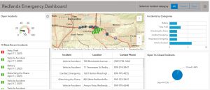
The book also highlighted the newer developments of ArcGIS Velocity, which is a real-time GIS product and has the ability to perform disaster recovery and is offered as a subscription. There are many new features/items that the Velocity offers to ArcGIS, such as feed items, real-time analytic items, and big data analytic items. Another point that I found interesting was the use of ArcGIS for dashboards in cars. I really enjoy the concept of dashboards (for data) in general, just because I believe that they communicate data in a very simple and straightforward way and are similar to infographics. So when the book touched on the use of ArcGIS dashboards, I was intrigued.

Application: For this chapter, I would like to create a web map that includes real-time layers. I’d be interested in looking at population levels in Columbus, OH and seeing how the levels fluctuate in real time. The reason I would choose Columbus is because it is such a large city with many different types of populations, so I think the data could be insightful.

Weber Week 5

Chapter 7 covered creating and navigating 3D web scenes. I learned about photorealistic scenes, which recreate real-world textures, and cartographic scenes, which turn 2D data into 3D thematic maps. It was interesting to see how different scene layers, like 3D objects and building layers, can be combined for detailed visualizations. I also explored tools like VR, AR, and indoor GIS for immersive mapping. A question I had was how large 3D scenes perform on mobile devices. Managing detail without slowing down seems important for real-world use.

For my application, I would create a 3D web scene of land use and ownership in Delaware County. Using parcel and zoning data, I would extrude parcels and color-code them by type, helping visualize patterns for planning.

White Week 5

For Chapter 7, I explored how to create and configure web apps using Web AppBuilder for ArcGIS. The chapter covered how to use themes, widgets, and map services to build interactive and functional applications that are user-friendly and highly customizable. I found it interesting how much flexibility the app builder gives users without requiring any coding knowledge.

One concept I found especially helpful was how different widgets can enhance user interaction. For example, the Layer List and Legend widgets provide clarity, while tools like the Query or Filter widgets make the app more dynamic for exploring specific patterns in the data. I also learned how to publish a map from ArcGIS Online and integrate it seamlessly into a Web App.

Application Idea

Using the Delaware Data from Geog 291, one idea I have is to create a Crime Density and Services Map. It would visualize locations of recent crime reports in relation to public services like police stations, hospitals, and schools. The goal would be to examine whether areas with higher crime incidents are underserved by key services. I’d use point data for incidents and facility locations, with buffers and density mapping to highlight spatial relationships.


Counahan Week 5

Chapter 7 focused on web scenes, beginning with an introduction to 3D maps and how web scenes work. It explained how to navigate within them and how to symbolize features effectively. The first tutorial was all about getting comfortable with the scene viewer and learning to move around within a web scene. In the second tutorial, I learned how to build a thematic web scene by creating a local scene and adding layers from ArcGIS Online. I also explored how to change the visualized attributes and experimented with different symbolization styles, using both 2D and 3D options. Adjusting the color scheme and the histogram range allowed me to tailor the layer’s appearance to match the purpose of the scene.

The third tutorial involved adding two separate layers and symbolizing all the points. I ran into some technical issues at first—nothing was displaying until I switched to a different browser—but once that was resolved, the rest of the tutorial went smoothly. In section 7.4, I learned how to add new features that could be positioned along the Z-axis, allowing me to place objects like helicopters in the air and buildings on the ground. Section 7.5 focused on editing these features; I added cars, adjusted their size, and changed the direction they faced. The final tutorial showed how to perform basic analysis using a web scene, like adding shadows that change depending on the date and time, which made the scene feel much more dynamic.

If I were to complete a project based on this chapter, I’d make a web scene of OWU. I would add features to represent different areas for example, placing cars in the parking lots. I think it would be fun to build a scene based on somewhere I know well, because I could make it very realistic and maybe even turn it into a sort of interactive campus directory.

Fondran Week 4

Chapter 6:

This chapter was interesting, and I enjoyed creating the Redlands Emergency Dashboard. It focused on spatiotemporal data and real-time GIS, two things I had not heard of before. The introduction was a great way to move into the tutorials and made everything easier to understand. It was interesting to see how you can get real time data, such as emergency calls and highway camera pictures. I can see how something like this system could be very beneficial for communities to track crime and see which areas could be underserved. I had a few problems with tutorials 6.4 and 6.6 because some of the buttons were hard to find. Overall, I enjoyed this chapter and learned more important aspects of the dashboard feature.

An application from this chapter on other data could be used for weather. Temperature gauges around the city of Delaware could relay the most up-to-date temperatures to the dashboard. This would allow people to dress or prepare accordingly to a more accurate temperature than their phone.

week 5

Chapter 7 was all about understanding the basic terminology of web scenes they give us opportunity to create web scenes using the same viewer. It was understanding the value and configuring 3-D maps. The two types of 3-D scenes we learned about were photorealistic and cartographic. The photo realistic were used to create features and cartographic used to do thematic mapping to display features. I learned as there is a lot of ways to represent 3-D images and data.

I think i will be creating a app off of the information from chapter 7 for my second app.

smith week 4

Chapter 6, demonstrates how screens can be used in real time. Chapter 6 divided spatiotemporal data Into four main types: change, stationary fixed, and moving each give you the ability to view different patterns and trends. I thought it was very interesting and will be extremely useful for the real-time data to be broadcasted to agencies like emergency response or environmentals or just companies that need real time feedback


Henderson Week 5

Chapter 7 was about web scenes.  It first introduced the basics of 3d maps and web scenes and then explained how to navigate them and symbolize them properly. The first tutorial was just about navigating web scenes using the scene viewer. The second tutorial taught me how to create a thematic web scene. I created a local scene and then added layers from ArcGIS Online. I then learned how to change what attribute to visualize and that there are different ways to symbolize those attributes (both 2d and 3d). I then could change the color and range of the histogram. There were many different ways to style the layer to make it fit what this scene was meant to be used for. The third tutorial had me add two different layers and symbolize all of the different points. I had trouble with this tutorial at first; nothing was showing up until I opened it on a different browser but after that it was quite easy.  7.4 was about adding new features that could be moved along the z axis (above or below ground). I was able to put helicopters in the sky and also add buildings to the scene. 7.5 was about editing features in the web scene. I was able to add cars to the scene and learn how to change the size and direction they were facing. In the last tutorial I learned how to do basic analysis in a web scene. I was able to add shadows based on the day and time and watch the shadows change as the day progressed.

If I were to do an assignment from this chapter, I would create a web scene of campus and add different features to represent different areas of campus, e.g., cars for parking lots. I think it could be cool to create a web scene based on a place I have been because I could make it realistic and almost like a campus directory.