My name is Hazel Jolliff I am a Junior and I took GEOG 291 before spring break so I have a bit of an idea of how ArcGIS works. I found it interesting to go through the online course and see how ArcGIS online works. I thought it was cool that you can make groups and organizations. I think that it is helpful to be able to share things . it was a good refresher about base maps and operational layers, I had almost forgotten about those.
My Searches:
#1. My search was “ GIS” and “Crop Damage”
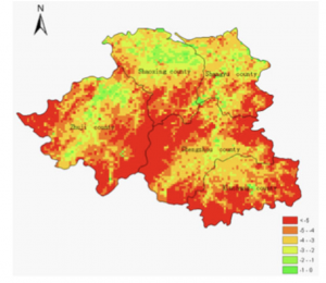
Reference: Lou, W., Ji, Z., Sun, K., & Zhou, J. (2013). Application of remote sensing and GIS for assessing economic loss caused by frost damage to tea plantations. Precision Agriculture, 14(6), 606–620. https://doi-org.owu.idm.oclc.org/10.1007/s11119-013-9318-5
The article titled “Application of remote sensing and GIS for assessing economic loss caused by frost damage to tea plantations” focused on developing a way to determine economic loss due to spring frost in tea plantations. The map used remote sensing and GIS to form a spatial distribution of temperatures in the given production area.
#2. My search was “ GIS Application” and “Archaeology”
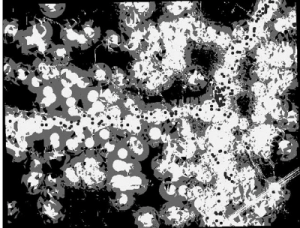
Reference: Ebert, D. (2004). Applications of Archaeological GIS. Canadian Journal of Archaeology, 28(2), 319–341.
The journal was titled “ Applications of Archaeological GIS”. This is an example of a predictive model, the dark circles represent existing sites that were used to base