My name is Trey Weber. I am a Junior on the Lacrosse team here. I’m a Finance major and I’m minoring in Economics. I am from Denver, Colorado. In my freetime I like to ski and work on cars with my dad.
I spent some time looking through last semester, but spent much more time exploring my ArcGIS Online account, and I was honestly surprised by how much it offers. The Training section is super helpful. It had tons of courses ranging from quick tutorials to in-depth lessons that span weeks.
One thing that stood out was the ArcGIS Blog and the Community forums. It’s cool to see how active the user base is, and I even found answers to a couple of things I was stuck on last semester just by browsing.
Through the “Intro to ArcGIS Online” page, I learned you can build and share maps in 2D or 3D, collaborate with others, and everything is saved to the cloud. I also didn’t know you could automate tasks in ArcGIS Notebooks or use Instant Apps to quickly turn your maps into interactive web apps.
The ArcGIS Online Basics course was also useful, it broke down different sharing settings (Private, Group, Organization, Public) and gave a good overview of app-building tools like Dashboards, StoryMaps, and Experience Builder. I really appreciated the step-by-step guidance and knowledge checks.
Overall, exploring the platform more deeply has shown me how much more ArcGIS can do beyond just making maps. It’s definitely something I’ll keep going back to throughout the semester.
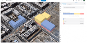
Urban Planning: Enhancing City Development
ArcGIS Urban is a web-based 3D application designed to improve urban planning and decision-making. It allows planners to visualize projects within their local context, analyze data, and create sustainable environments. By evaluating multiple zoning, land-use, and development scenarios with 3D visualizations and urban analytics, stakeholders can address challenges such as housing shortages and climate resiliency.
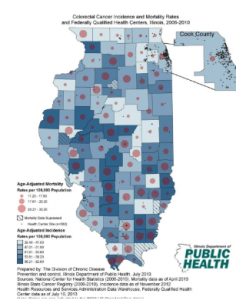
Public Health: Improving Health Outcomes
ArcGIS Online is utilized in public health to enhance health outcomes, increase accessibility to healthcare, and build healthier communities. By applying GIS, public health professionals can identify coverage gaps, improve workflows, and plan for unforeseen events. This spatial analysis leads to better resource allocation and more effective public health strategies.
Sources:
https://www.esri.com/en-us/arcgis/products/arcgis-urban/overview?