Hi everyone! My name is Maggie, I’m a senior and I am a psychology major and business minor. I’m taking this class because my roommate is a geography major and recommended that I dip my toe into the geography world (I also needed a 0.5 credit to graduate in May). I’m excited to learn more about geography and to have a little challenge during the last half of my senior year spring semester. In my free time, I enjoy doing puzzles, playing Fortnite, and hanging out with my cat named Frankie (she is perfect).
After looking through the account settings and poking around this website, I found that I enjoyed the idea of being able to set my own color theme for my viewing pleasure. I also liked how everything seemed pretty straightforward and easy to navigate.
One notable and interesting idea I learned from the reading for this week was that you can add layers to your maps with ArcGIS and allow other users to view/use them as well. Another thing I noticed was how detailed and helpful each section was for certain actions one can take in ArcGIS. I will definitely be referring back to this article when I need assistance or clarification in the future!
I did not take 291, so for my free training this week I completed the ArcGIS online basics course. One of the first things I learned from this course was the different types of web layers and their purpose/function. I also received some practice actually working with a map in the website which is something I had never done before, so I enjoyed that!
ArcGIS Online Basics_Certificate_03212025
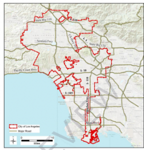
In regards to my Google Scholar search, I was interested in seeing anything having to deal with cats. The first article I came across was about the distribution of feral cat trapping permits in Los Angeles, California. In this area of California, and in other urban areas, feral cats are an increasing problem. In this specific area, there is an estimated amount of 3 million feral cats, and only specific places have permits to legally trap feral cats for a multitude of reasons. The following map shows a distribution of locations where forms/documents have been filled out by individuals when trapping a feral cat.
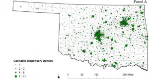
An additional application I was interested in was the number of cannabis dispensaries in specific areas in the United States. The state that came up in my search was Oklahoma, which I know nothing about and so I thought that was intriguing! The following map shows the density of cannabis dispensaries in the state of Oklahoma.
I really enjoyed the time I spent learning the basics of ArcGIS and I am eager to continue using this website to expand my knowledge in this area.
Sources:
Kingsley, G. (2015). Distribution and correlates of feral cat trapping permits in los angeles, california (Order No. 10800044). Available from ProQuest Dissertations & Theses A&I. (2067466408). Retrieved from https://owu.idm.oclc.org/login?url=https://www.proquest.com/dissertations-theses/distribution-correlates-feral-cat-trapping/docview/2067466408/se-2