Hello; my name is Emily Keckler. I am a freshman majoring in Environmental Studies. I did not take GEOG 291, so this is going to be a fresh experience for me- especially since I have very little background with geography in general.
Looking into my account I found that I have 1,000 credits to use, and- looking further- I found that there are certain online courses that require an exchange of these credits. This is particularly interesting and peculiar to me as using this program already costs a decent chunk of cheese, so it tickles me that there are additional exchanges in order to access certain “premium” content- even after purchasing a “premium” account.
There is also a robust GIS community on this platform- blogs, forums, community posts, articles, etc. I intend to take advantage of these for questions and other troubleshooting when I inevitably encounter something new.
In “Get Started: What Is ArcGIS Online” I read into the basics of viewing scenes and maps. Now, I can have a better idea of the different capabilities that I have when interacting with media on this platform. From there, I read into the different types of maps including time and floor-aware maps.
I also began to look into the process of making an app. There are many aspects to consider when putting one together including: the type of app, audience, creating a map, inclusion of photos and text, etc. Collaboration and engagement are a particularly critical aspect in utilizing GIS to distribute information within an organization, group, or publicly, so extra emphasis is placed on that throughout the overall reading.
When I did the “ArcGIS Online Basics” web course I was introduced to some GIS terms, and I was able to familiarize myself with different types of layers alongside their sources. In addition, I made a map of mountain trails, got a little bit of experience with navigating a map, and I learned some of the various app builders under the ArcGIS umbrella. Upon completion of the course, I was left feeling a bit lost on navigating maps.
Since I did not feel very confident in my understanding of GIS from the first course that I took, I decided to take a second one- “Exploring GIS Maps.” This second course revisited some of the aspects of the first which made me feel more comfortable in being able to navigate maps and placing bookmarks on certain locations.
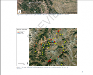
For GIS application areas, I decided to look up “ArcOnline Superfund Sites,” and I found a master’s thesis on the acid mine drainage around superfund sites within the Bonita Peak Mining District (Dorsk, 2020).
From: “Using Rare Earth Elements and Geochemical Patterns as In-Situ Groundwater Tracers at the Bonita Peak Mining District Superfund Site”
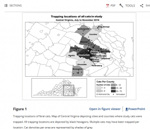
I also chose to search “ArcOnline Trap Neuter Release Cats.” An article that piqued my interest used information from a Central Virginia Trap, Neuter, Release (TNR) program of feral cats trapped within areas also populated by people to assess the risk of feral cats transmitting diseases (such as rabies) in local parks, schools, etc. (Taetzch, Bertke, & Gruszynski, 2018).
From: “Zoonotic disease transmission associated with feral cats in a metropolitan area: A geospatial analysis”