https://owugis.maps.arcgis.com/apps/mapviewer/index.html?webmap=d48f82d6a2e844f4958f5b265a9abe55
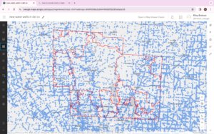
For my first application I created a map of Delaware County, OH and the zip codes within. I then used ArcGIS online to search for all water wells in Ohio. All of the blue dots are locations of water wells sites. I feel this application would be useful seeing how many people still use a well today or are reliant on city water.
https://owugis.maps.arcgis.com/apps/webappbuilder/index.html?id=e49e6fc8084544b3ba7ae7202b161b8
For my 2nd application I used the ArcGIS Web AppBuilder to display an interactive web page display of Ohio and all oil and gas fields. Using the App builder and this theme you can search for an address or place, find the legend, filter, and also have directions from one location to another. I think an application like this would be useful for having to visit multiple locations in a short period of time. The blue dot is your current location and is a feature you can choose to add.

