Hi! My name is Jonathan Munroe. I’m a junior from St. Louis, Missouri majoring in geography and minoring in music performance.
I already completed the first few steps in this week’s posting during the last course and have had an Arc account since freshman year. Two things I noticed when looking through my account were:
- I didn’t have a bio. I decided to create a brief bio including my hometown and major/minor.
- I went through all my old projects to review what I’ve completed in the past. I had forgotten how many storymaps I’ve made through the years, creating projects for Urban Geography, Geography of Pop Culture, Science Behind Climate Change, Cultural Geography, and The Power of Maps and GIS.
Two things I learned from Get Started: What is ArcGIS Online
- Slides. I learned that slides let you capture the state of the scene. This is helpful when needing to tell a story through your map, especially when needing to show the difference between factors like camera position, daylight settings, etc. To do this, click slides on the designer toolbar, click capture slide, name it and hit save. This will capture the scene of your map at this moment, and allow you to return to it as it has been successfully saved.
- Floor-aware maps. These maps contain GIS data from inside buildings and organize it into floor-aware layers, good for visualizing indoor spatial data. To do this, click map properties on the contents toolbar and find the indoor layers section. From there, turn on enable floor filtering and select the layers that correspond. You can also specify additional line, point or polygon feature layers. Click save and it will be added to the map.
Training Course
- I already completed the web course for ArcGIS Online Basics so I found a course titled Create a Web App in ArcGIS to Share Digital Exclusion Data. This course utilized ArcPro and ArcOnline to show how the two programs work together. Two things I learned were:
- How to utilize pop-ups with graphs to better display data for specific counties
- How to create and apply web apps onto my online maps.

Two Articles:
- Yolanda F Wiersma and Randolph Skinner: Predictive distribution model for the boreal felt lichen Erioderma pedicellatum in Newfoundland, Canada
- This application took forestry data from Newfoundland and information regarding boreal felt lichen habitat suitability and applied it together to create a map highlighting the expanse of where this species would grow in Newfoundland

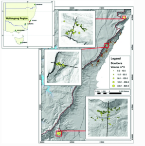
- Phil Flentje, Darshika Palamakumbure, Jack Thompson: Assessing Rockfall Along the Illawarra Escarpment
- This application mapped rockfall data from the Illawarra Escarpment surrounding Wollongong, where I studied abroad in the fall semester, using 2D and 3D modeling.