Jenna’s Plants of Alaska

I would consider myself more of a biologist than a mathematician, so during our trip, I spent a good amount to time observing the Alaskan wildlife. After our boat tour and a few long car rides I decided that I needed to make a list in order to remember all of the plants I have identified.  I was somewhat limited in the number of plants I could identify from the car because 1) I forgot to bring an Alaskan plant field guide with me and 2) I kept making myself nauseous by looking at individual plants as they zipped by at 60 mph.  So I haven’t included everything that I saw, of course, but at least the ones that I think were most interesting. Here is my list so far:

black spruce (Picea mariana)

paper birch (Betula papyrifera)

Sitka alder (Alnus viridis)

black cottonwood (Populus nigra)

cow parsnip (Heracleum maximum)

lupine (Lupinus sp.)

lichens (black, orange, green)

moss

cotton grass (Eriophorum sp.)

Labrador tea (Rhododendron tomentosum or neoglandulosum)

Reindeer lichen (Cladonia rangiferina)

 If you take a snapshot out of your car window on the average Alaskan highway (or at least on the highways that we have been using), you will probably see a mixture of spruce, birch, cottonwood and alder, so these are the plants that I have seen the most of during this trip.  It seems to me that there is much less plant diversity in Alaska than in Ohio, but conditions are also much harsher for plant life at such a high latitude.

We saw this alder near UAF. You can see the male catkins (green-yellow structure, top left) and female catkins (brown and shorter, bottom right) pretty well here.

We saw this alder near UAF. You can see the male catkins (green-yellow structure, top left) and female catkins (brown and shorter, bottom right) pretty well here.

We spent our first night in Alaska in Eagle Creek, and after dinner we went on a walk through the woods.  That is where we saw the gnarly cow parsnip shoots coming up out of the forest floor (sadly, I forgot to take a picture).  These giant relatives of Queen Anne’s Lace, both members of the Carrot Family, are very common in Alaska, can grow up to 7 ft tall, and can irritate the skin and cause rashes.

photo credit: oregonstate.edu

Cow Parsnip (photo credit: oregonstate.edu)

When we visited Exit Glacier near Seward, AK, we hiked up a steep mountain-side trail toward the ice field.  While we were still in the valley near the glacier front Ben kept asking what was giving the woods such a fresh, nature-y smell. Dr. Jackson finally narrowed it down cottonwood trees whose leaves were just beginning to open.  I looked it up later and found out that black cottonwoods, common to Alaska, give off a strong, balsam scent as their buds open in the Spring.

This sapling was growing on the moraine of Exit Glacier. They are tough little trees!

This black cottonwood sapling was growing on the moraine of Exit Glacier. They are tough little trees!

The next day we wound our way up into the mountains again to Eklutna Lake and Glacier.  We camped near the lake for two nights and while we were driving out to see the pump station, I spotted purple lupines growing on the banks of the road.  I love lupines, but sadly they have done poorly in our gardens at home. It’s amazing that they are just growing wild here, brightening up the landscape in the springtime.

photo credit: www.kitinak.com

Lupine (photo credit: www.kitinak.com)

After Eklutna we went over to Matanuska Glacier where we set up the weather station. While trekking over the glacier to find a good spot for the tower, we spotted lichens and mosses growing on the rocks in the moraine areas.  There were mostly black and green lichens but also what seemed like orange in other areas, and all mosses were green.  Lichens and mosses are often the first species to inhabit the moraine (rocks and silt) left behind by glaciers, so they are often used to determine how fast a glacier is retreating.

Many of the rocks were tinted orange, green or black from the many mosses and lichens.

Many of the rocks on Matanuska Glacier were tinted orange, green or black from the many lichens and mosses.

A few days later we visited the Poker Flat Research Range to see the observation tower used for ecological research.  While at Poker we saw many more black spruce and paper birch.  Black spruce is able to grow on permafrost while white birch is not, so if you want to know where the permafrost areas are, you may want to look for the patches of black spruce! Black spruce also has special adaptations to fire. A few years ago a huge fire spread through Poker, burning the plants and ruining some of the research equipment.  However, the black spruce were able to repopulate the area after the mature trees were burned down because of the seeds that were left in the soil. Fires are a natural part of this ecosystem, so many of the plants here are able to regenerate their populations after the destruction. At many points during the trip we have been at high enough elevations which were very close to the tree line, or the point above which conifer trees cannot grow.  Above this line temperatures are too cold and moisture is too low to sustain tree growth.  So even black spruce, which can grown on permafrost, cannot grow above this line.

Black Spruce

Black Spruce

paper birch

Paper Birch

One of the post-doctoral researchers at the University of Alaska, Fairbanks is studying the understory plants of the open spruce forest in Poker, so he showed us many of the plants with which he is working.  We saw cotton grass, Labrador tea, reindeer lichens, ground cranberries, and moss, which covered the whole forest floor of Poker.

cotton grass

Cotton Grass

laborador tea

Labrador Tea

Cranberries from last season and white caribou lichen

Ground cranberry and reindeer lichen

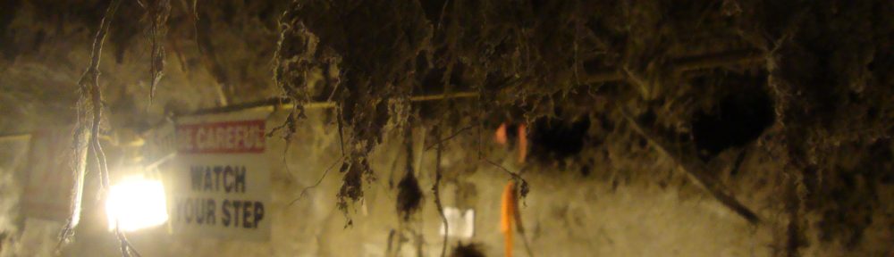
Finally, when we visited the permafrost tunnel, our tour guide showed us some of the most amazing plants of the whole trip.  While ~200 m under a mountain, we were able to see permafrost dating back many thousands of years.  In many areas were remnants of roots hanging down from the ceiling. At one point in particular, our tour guide showed us some grass stems that were intact and still green! He guessed that were ~20,000 years old! I had no idea I was going to see something like this in Alaska!

Here were some of the roots hanging down from the permafrost ceiling.

Here were some of the roots hanging down from the permafrost ceiling.

Our guide with a stem from the ~20,000 year old grass

Our guide with a stem from the ~20,000 year old grass

Even though the plants of Alaska are pretty different from the Ohio and Pennsylvania flora that I am used to, I enjoyed learning so more about them in the most unlikely places. Even Dr. Jackson taught us a lot about the Alaskan plants! But next time I come to Alaska, I will be sure to bring my field guide.


The Chatanika Gold Dredge

Our Alaskan adventure was filled with daily surprises, and one that excited me the most was our visit to the Chatanika Gold Dredge.  Located east of Fairbanks on the way to Poker Flats, Gold Dredge #3 (as it was originally called) sits abandoned on a small lake just off the Steese Highway across from the Chatanika Lodge.

Chatanika Gold Dredge

The Chatanika Gold Dredge as of May 2014.

You’re probably looking at the picture above and wondering “what a heap of junk.”  Indeed, this dredge was destroyed by a fire in August 2013.  The story goes that two guys were playing with the levers when a pulley sparked causing the whole ship to catch on fire.  You can read more about it here and here, as well as see pictures of it burning.

dredge3

Dr. Jackson and the first batch of climate modeling students toured the dredge in 2012, before the fire.  They boarded and explored it.  You’re probably wondering how this dredged look before it was destroyed.  It was beautiful.

Dredge2

dredge4

dredge5

dredge21 dredge1

dredge20

Here’s a 360 degree panorama shot.

This picture illustrates how it works.

dredge-8-fairbanks

Here are some pictures of the levers that raised and lowered the massive chainsaw-like bucketline.

OLYMPUS DIGITAL CAMERA

The bow gantry and bucketline, robbed of its magnesium-steel bucket-teeth.

Dredger

Looking up the bow gantry.

This website contains some good pictures of the dredge buckets of #3’s sister dredge, Dredge #8.  More pictures of our Chatanika Dredge #3 can be found here and here.

Urban exploring is one of my favorite hobbies.  It’s the thrilling combination of legal risk, personal danger, and a sense of traveling back in time that appeals to me.  It sometimes gets me into trouble, and sometimes it leads to interesting outcomes.

For example, as an REU student at OWU during the summer of 2012, I persuaded some fellow REU students to explore the abandoned OWU Student Observatory with me.

OWU Student Observatory

The abandoned and nearly condemned OWU Student Observatory.

We ended up getting caught in the act by the police and a K-9 unit.  Rather than getting dismissed from the REU program, my advisor laughed and invited me to transfer to OWU.  How could I refuse?

So when I saw the Chatanika Dredge, I knew I had to board it.  Dr. Jackson was not one to hold me back, despite it being extremely unsafe.  After boarding, the wind and the creaking and groaning of old rusting steel made me extra cautious, at times wishing I had a hard hat (or my red glacier mountaineering helmet).  The deck was a mess, and it was difficult to move about.  I did snag a few pictures of the inside.

IMG_1798

IMG_1796

IMG_1799

After exploring the inside, I took a look up at the bow gantry (see earlier diagram), which had a narrow ladder running up it.  Dr. Jackson probably saw the direction of my gaze, and challenged me to see how high I could get.  Normally I face resistance in these matters, but not with Dr. Jackson.  Excited, I carefully climbed up to the tippy-top, and snagged a few more pictures.

IMG_1802 IMG_1803 IMG_1804

Here are a few videos of other people exploring the dredge pre-fire and post-fire.

The urban exploring code of conduct is to never damage, vandalize, litter, break (to enter) or otherwise disturb anything in the building or structure you explore.  Only trespassing is allowed.  It’s a shame this magnificent and historic dredge fell victim to explorers who didn’t abide the code.

Bike Ride along Lake Eklutna

After our first night of camping, Dr. Jackson cooked us a traditional Alaskan frontier breakfast of Spam, eggs, cheese, on English muffins, aka Jackson McMuffins. Not being one to subject my body to abominably unhealthy food like Spam (it’s 28.5% fat and high in sodium), I adopted the “When in Rome…” ethos and ate three Jackson McMuffins, plus a raw sliver of Spam just to give myself an extra punch in the gut. Ben repeatedly described the Spam as “delightful,” and shortly thereafter Whitney complained of heartburn. I’m sure I filled my body with close to 1500 calories from that breakfast, but I would need the energy. The plan for the day was to rent bikes and ride the Eklutna Lakeside trail, which runs along the lake up to the Eklutna glacier.

Eklutna Lakeside Trail trailhead.

Eklutna Lakeside Trail trailhead.

The attendant at the bike rental shack claimed the bike trail was 14 miles long, followed by a hiking trail up to the glacier. I estimated that by adopting a leisurely pace of 10 mph, we could reach the end of the bike trail in an hour and a half. Nobody knew how long the hiking trail was after that, but I hoped we’d at least be able to view the glacier from the bike trail.

Dr. Jackson meeting the attendant at the bike rental shack.

Dr. Jackson (in red) meeting the attendant at the bike rental shack.

Depending on the vagaries of the terrain, the trail split into a relatively flat bikes-only section that ran near the lake, and a parallel ATV (all-terrain vehicle) path that climbed up the mountain and then descended to rejoin with the bike path. On the way up to the glacier, we faithfully kept to the bike trail. This path offered more scenic views of the lake and mountains, but frequently had large sections that had collapsed from erosion.

Ben taking in the majestic views of Lake Eklutna.

Ben taking in the majestic views of Lake Eklutna.

The weather was sunny and warm, making it a beautiful day in Alaska for a bike ride.

Eklutna Lakeside Trail

Jenna leading the pack on the Eklutna Lakeside Trail.

Segments of trail were fully missing such that we had to carry or walk our bikes until the path reappeared. The first one I took rather fast and clipped my left arm on an array of small trees, losing a nontrivial amount of skin. But mostly these tight sections required only slow and careful riding, and perhaps a prayer that the land wouldn’t sink beneath us.

Eroded trail.

Whitney and a moderately eroded section of trail.

Around the six mile marker we passed the lake and found ourselves coursing through several acres of forest recently marred by wildfire. We were surrounded by dry yellow brush and a scatter of scorched-black tree trunks. The air was filled with an arid, breathless silence highlighting an absence of wildlife. Such landscape will make one’s throat dry, and the group stopped for a water break. I started grumbling with the suspicion that this was the work of some negligent campers, but Jenna, our resident botanist/chemist, explained that wildfires were a natural part of a forest’s lifecycle, which made me feel better. Natural wildfires are A-okay in my book.

Wildfire area along Eklutna trail.

Jenna and the wildfire area along Eklutna trail.

Shortly after the eleven mile mark we crossed a small, gently flowing river which carried the main glacier runoff that fed the lake. Our pace was about 4.5 miles per hour by this point, and some of us were having trouble with our bikes shifting properly. We decided to break for lunch on a sandbar in the middle of the river.

Our picnic spot.  We sat on that fallen tree trunk.

The sandbar that became our picnic spot. We sat on that fallen tree trunk to the left.

By this point I had run out of water (the Spam sodium had hogged my water supply), and Dr. Jackson advised that I not drink the river water due to the risk of contracting giardia, which is a bacterial infection producing violent digestive problems.

After lunch, the trees and river (or perhaps his food) struck Ben with the impulse to meditate. The others found themselves some rocks to sit on and politely waited for him to finish. I just stared at all this cool, fresh glacier water rushing by me. “Water, water everywhere, but not a drop to drink” goes the The Rime of the Ancient Mariner. It was a only a few hours back to camp, so I wasn’t worried about shriveling up into a raisin.

Our picnic area looking down river at the bridge along the trail.

Our picnic area looking down river at the bridge along the trail.

But I came close. On the return trip, we accidentally took one of the ATV trails, which was drastically more difficult. It was rockier and had larger elevation changes, which substantially slowed down the group. And to our dismay, it was over a mile long! Future bike riders, heed this warning: Do not ride the ATV trail!

The trail splitting into the bike trail to the left and ATV trail to the right.

The trail splitting into the bike trail to the left and ATV trail to the right.

Finally, we made it back to the bike shack, and I drank one of the most delicious gatorades of my life.

Should have done more squats…

The one thing that I did not expect before coming to Alaska was how physically demanding it was going to be. I knew beforehand that we were going to do some hiking and that we were going to bike around a lake and that we were going to climb a glacier, but I honestly thought that it would be a piece of cake…boy was I wrong!

Being on the tennis team for OWU, I definitely thought that I would be in good enough shape to be able to easily do all of the activities we had planned. The team had just gotten a new tennis coach this year and he had us in the weight room doing things that I had never done before. I thought surely that if I am able to complete the weight room routines that Alaska would be a breeze. After being in Alaska for over a week now and having completed all of our outdoor activities I can admit that I was wrong. I was way wrong.

I got my first taste of my physical weakness when we started to hike the path along Exit Glacier in Seward toward the ice field. If we made it all the way to the top, our round trip would have been around 8 miles. We started the trail at a fairly swift pace and after going just a short ways I knew I would not be able to keep that up for long. I stayed in the back and just sort of huffed and puffed my way, not stopping but definitely not going the same pace as the others. I thought I was the only one that was struggling so I just kept hiking, not saying anything, but also not going fast by any means. After we had been hiking for what seemed like quite some time, we decided that it was probably best if we stopped our upward ascent. I was very relieved to say the least, but the view from the side of the mountain was totally worth it. In the end, I think we ended up only going about a mile up the mountain, but it definitely seemed a lot longer.

resize

Jenna and I at the height of our hike

After we left Seward, we went to Eklutna Glacier where I faced my biggest challenge…mountain biking. Like every other kid, I loved to ride my bike up and down my street for hours. The rush of wind in your hair, the excitement of being able to ride in the street, the joy at trying to peddle with no hands, these were the thrills of riding a bike that I enjoyed when I was younger. All that being said, I was really looking forward to biking around Eklutna Lake and I was up for the adventure. As soon as we got our bikes and started heading out on the trail, I quickly realized that this would be no easy feat. Not soon after we started, it became clear that I was the slow poke of the group and they would get quite a bit ahead of me and then would have to stop to wait for me to catch up. This continued for pretty much the whole ride and I quickly became frustrated that I was the one holding everyone up. I was timid on the bike and wary of letting go of the breaks anytime there was a small incline to go down. Some parts of the path were extremely narrow and we had to walk our bikes in order to not fall off a small ledge and other parts of the trail were just covered in rocks. I’m pretty sure I was better at riding over every big rock than I was at avoiding them.

After riding 11 miles one way we finally came to our stopping point to eat our lunch. We headed down to eat next to a small river that had beautiful mountain views. I think the scenery made the trip all worth it, but in the back of my head I knew we still had 11 miles to make it back to where we started. These 11 miles back definitely pushed me to my limit and I was feeling pretty defeated. My legs were sore and starting to cramp, my back hurt from bending forward, and my butt was definitely getting the worst of it. Even though I had to walk at some points, I knew I just had to keep going and there was no other way to get back. Once we reached the home stretch, I had Jenna take my picture with my bike to prove that I had made it because I probably would not be doing anything like it ever again.

resize bike

Me with my bike at the end of the trip

Overall, I am really glad that I had these two experiences because when would I ever get to do something like this ever again. I have so much more respect for avid mountain climbers and avid mountain bikers. The physical and mental strength it takes to do these two things is exponential and I applaud anyone that does these two activities on a regular basis or even just attempts them once like I did.

If you plan on traveling to Alaska to do any of these outdoor activities, I have one piece of advice for you…do lots of squats beforehand!

Thar She Blows

Yesterday we arrived in Seward AK, which in my Ohio-an estimation is one of the mountainiest places I’ve ever seen. Seward is a port city, incident on the very Russian sounding Resurrection Bay.

photo 1

Figure 1: Resurrection Bay

The first thing on the agenda yesterday was a 6-hour boat trip out to the Holgate Glacier. We left the bay in good spirits, I took a ridiculous Titanic picture, with my arms outstretched on the bow of the boat. I was promptly told that everybody does that, which did burst my bubble just a little.  We saw a humpback whale in the bay, and a pod of orcas, all just hangin’ out.

photo 2

Figure 2: Orcas chillin.

Then we entered the ocean to navigate around a peninsula, which stood between us an our glacier. And I, almost immediately, turned green…  Despite my Scandinavian heritage, I get terribly seasick. So the next three hours were quite unpleasant. Eventually the Dramamine I had taken kicked in and I feel asleep on the second deck.

Thankfully, Richard kicked me awake when we reached the Holgate Glacier Even in a drowsy, nauseated state, the cool blue glacier ice was unbelievably beautiful. We hung out in the bay and watched chunks of ice crumble off the face of the glacier. I even managed to compose myself enough to take a duck-face selfie with the glacier…
#selfie-triumph

Figure 3: Selfie with the Holgate Glacier

Figure 3: Selfie with the Holgate Glacier

Travels in 2012

Below are some GPS tracks from the 2012 Alaska trip.

First is the route we took driving across Alaska. We started in Anchorage, then went south to Whittier, a small coastal town out of which we took a charter to see tidewater glaciers. For this trip in 2014 we went further south to Seward since (1) Seward is a more interesting town than Whittier and (2) there were no charters out of Whittier during the time we were going to be there.

After Whittier we went north towards Glen Allen to spend 3 days at Matanuska glacier. We will be doing this in 2014 as well!

Our last visit in 2012 was to Fairbanks in central Alaska. We spend two full days having a mini-summer school at the International Arctic Research Center at the University of Alaska Fairbanks. We visited several research sites as well.

After Fairbanks we traveled south by the Parks highway back to Anachorage to catch our flight home.

ak_small

Above: Alaska travel route.

matanuska

Above: Two solid days of treking across the Matanuska glacier. The furthest point south is where we set up our weather tower (see older posts on this topic).

whittier

Above: Our route out of Whittier to see Blackstone and Beloit glaciers.

Let the Countdown Begin!

It feels like just yesterday that I was signing up for this course and now we are only a week away from leaving for Alaska! The only thing standing in our way is a week of finals and graduation for the seniors.

In preparation for our travels and glacier climbing I have had to do some shopping for things like a good rain coat, hiking pants, and mountaineering boots. I bought my boots over a month ago and it seems so crazy that I will finally get to put them to use in a little over a week!

photo


After learning about the climate and glaciers all semester I am looking forward to using this knowledge while traveling around Alaska. This will definitely be a once in a lifetime experience and I cannot wait for our journey to begin.