Tracing water and electric lines

This week I was able to use the as-bill maps to trace the water and electric lines for 2 of the parks that need to be mapped. I was able to associate the maps just through landmarks visible in ArcMap. These added graphics were transferred to layers as a part of the geodatabase. I plan to continue doing this with other locations.

However, I won’t be able to do this with all of the maps. There are some parks where the trees make the roads untraceable on ArcMap. For some others, the as-bill map gets too distorted when I try to associate them to use them. For these I’ll have to go out with the GPS to get better data to associate the maps with or go out with the utility line locator to trace them in the field.


Harvey post 5

Another great week at the internship following spring break. On Monday janelle taught me how to use blueprints and georeferencing to create a new utilities map. After giving me the run down in how it works she let me work on Arc from her desktop, since it has more capabilities and is easier to use then my laptop, and set me free to create this utility map of a new subdivision. I spent the rest of the afternoon adding in the water, sewer, and storm infrastructure. This included adding structures such as inlets, manholes, fire hydrants, valves, laterals, junctions, and a few others. After the map was completed it was very rewarding seeing the finished product! It was a great experience and an even better learning opportunity!

On Friday janelle had me continue the same type of work but on to a bigger and more complicated scale and with a new development.   This time janelle taught me how in import csx and cad files into arc online as well as how to munipulate these layers and how to use a query when looking for something specefic. For this project I was drawing in the utility infrastructure using the engineering cad files. This was a bit more complex then simplying drawing in the lines from the blue prints like we did Monday.  At first I was a little overwhelmed but as I got into I really enjoyed the task! Janelle even had the confidence to leave me alone while I continued this work and when she came back all was good, which was a relief. A big part of this was modifying the lines that were previously drawn in and this proved to be more time consuming then expected and I only got the water infastruce completed. So we plan to continue the process on Monday and finish up the sewer and storm infastructure!


Using ArcGis to make a Masterpiece

So for the last two weeks I’ve had the pleasure of using ArcGis to map out a building. The building that I’m mapping is rather large and is comprised of 3 floors and also has several smaller buildings surrounding it. It also has its own large pond which is pretty cool.

During this mapping process I’ve had to think outside the box a little to make sure that my end goal i.e. a complete layout out of the building, works together as a cohesive unit. This means deciding on how exactly I want to display the data I have within ArcGis. I think I’ve settled on a way to do this that makes sense but the only way to really make sure is to view the end product.

Needless to say this project has made me realize that there are a lot of things within ArcGis itself that I don’t really know how to use to there best potential. I understand that hands on experience is key for understanding the software but there are a few things that I wish would have been covered in my classes more extensively.

Beyond this though the experience that I’m gaining is quite invaluable. Michelle is showing me ways to use the software that streamline and speed up the mapping process. Being able to find shortcuts and work arounds within ArcGis makes mapping go a lot smoother and speeds up the process. Not to metion that the final layout will be better organized.

Beyond just mapping though Michelle has let me know that I’ll be scanning actual building blueprints for the fire department. That is something I’ve never done before and it actually sounds quite interesting. I’ve gained a lot of appreciation during my time at the fire department for how important Michelle’s job is for the city of Delaware. Trying to create an interactive layout for Delaware is no small feat and I’m happy to help.

How to Write for Social Media

Writing a social media post can be one of the most difficult parts of marketing, especially for small business owners. There are some important keys to remember when writing a social media post!

Register is vital to remember when posting. Too informal and you lose the professional feel that is key to managing a small business. Too formal and you risk boring your audience and getting lost in the static.

This week I worked with Phoenix Environmental on writing social media captions for their Google account and Facebook page. A common mistake among social media managers is very formal and stiff writing, but nowadays we expect businesses to be more sociable and friendly on social media.


On site with Phoenix Environmental

In my last post I discussed the importance of content marketing for a business such as Phoenix Environmental. Since then I’ve worked with Jeff to explore ways we could accomplish this and other goals we generated in the Comprehensive Social Media Plan.

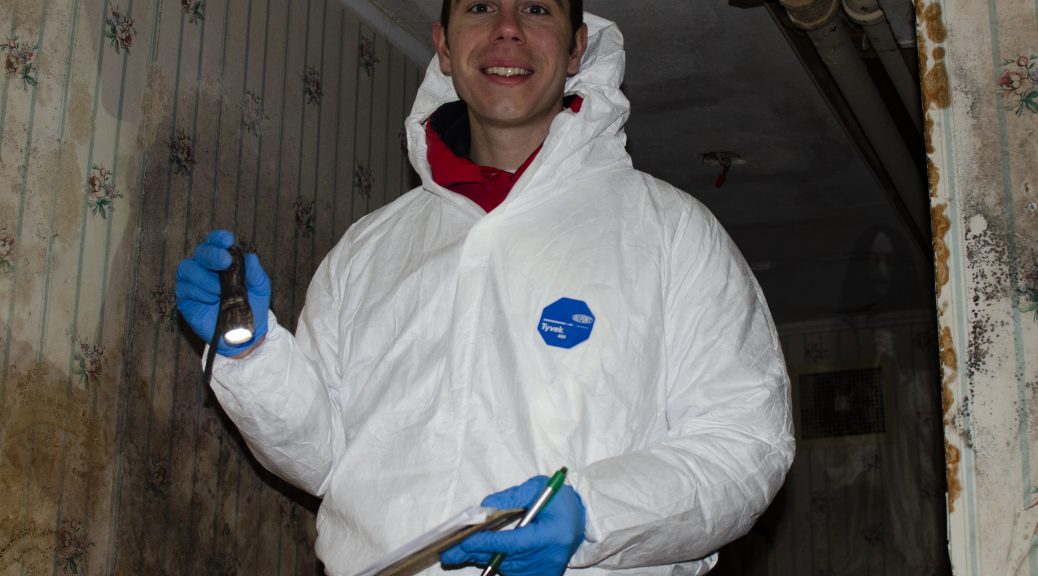
Earlier this week I worked on site with Phoenix Environmental for the first time. I worked at a location that was built in the 1820s and has since unfortunately fallen into decay. The likely location of America’s next Annabelle sighting, mold tags the walls like graffiti. Orange light pours in from stained glass windows and casts an eerie glow on an already terrifying setting. Light switches filled with several ounces of mercury line the walls. Yet, the sighting that most offended my eyes was the awful wallpaper the interior designer chose for the bathroom. Blue stripes… what was he thinking?!?

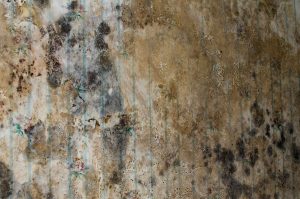
While on site I learned about asbestos and mold testing, how to take soil samples, and about how amazing I look in a hard hat. This first site assessment was mostly educational for me, although I had the chance to take some shots of the asbestos tests and soil samples! Pictures are a key part of content marketing and of showing our audience what it is that we do at Phoenix Environmental. Aren’t these photos bad for marketing, though? Aren’t my descriptions of the site as a horror house dangerous for Phoenix Environmental? Look at these pictures and realize that this is why you should call in environmental consultants like Phoenix Environmental as soon as possible! It’s better for us to find the problem before it becomes a problem, and that is the content marketing these pictures highlight.

One problem that makes taking photos (and writing posts like this one) especially difficult is that Jeff and his team highly value privacy, so all pictures and descriptions must strictly avoid giving away the location of a project. This is a creative challenge for marketing, but one I look forward to working around.

In the near future I’d like to join Jeff and his team on site and produce a video showing some of the work that Phoenix does, so be on the lookout for that!


Testing GPS transfer and Learning to Read Utility Maps

This week I brought the GPS that I will be using to mark the utility lines to the office. I made a test point to see if I was able to transfer the point onto ArcGIS. I was not able to do this due to an issue with the communications port.

I was able to resolve this issue by putting the coordinates from the GPS into ArcGIS through the ‘Go to XY’ tool. I was able to turn this into a layer in the geodatabase via the ‘convert graphics to features’ function and then that was added as a layer to my map.

When I try to do this with multiple points I think it would be more efficient to make a table of all of the points for a line on excel and then add the whole table as a layer. I’ll be able to do this at school throughout the week and then bring the tables to the office on Friday via a flashdrive. I’m considering converting the excel file to a .dbf file before I try to transfer it because I know .dbf files transfer more easily than excel files.

Also, Janelle Valdinger came in today to teach me how to read the maps of property utility lines. We were able to get maps for some of the parks and should be able to use them directly to map the utility lines on ArcGIS. I’m going to look into the possibility of converting a PDF document to a jpeg and then being able to assign geographic data to it. The maps that we were able to get are well marked which makes them easier to understand and use.

Harvey Post #4

This was an interesting week with a change in schedule. I did not report to the public utilities office at all this week, instead I spent my hours shadowing a Delaware county game warden. Janelle has been excellent indirecting me throughout my internship but also going above and beyond to help me search for jobs post graduation. She was the one who set up this shadowing experience with the game warden and I am very grateful. The game warden, Maurice Irish, walked me through a typical work day for him. Since it is a slow time of year with no hunting or fishing going on we spent most of the time driving around different parks and wildlife areas to ensure everything was running as it was supposed to be. Maurice also took the time to tell me about what he does during different times in the season, his favorite parts about being a game warden, as well as his least favorites. Maurice gave me lots of good tips and advice to think about when preparing to apply to be a game warden, including things to do in the meantime and what to expect if I get selected. Maurice also talked to me about other aspects to his job that most people do not think about, such as education and public outreach. As part of his job he gives a lot of presentation and even pulled up a few to give me an idea of what that entails. All in all I really think this is the type of career I could see myself doing!  Although we did not get to do a whole lot of hands on things today, I found it quite interesting and very helpful just to talk with Maurice and get his views and opinions on what being a game warden is really like. Towards the end he gave me his card and invited me to partake in another ride along whenever I get the chance and I look forward to taking him up on that offer.

My first few weeks working for the city

Hello to anyone that actually reads this my name is James and I’m an intern with the city of Delaware more specifically I’m working with the Delaware fire department. Since this is my first post I’ll try my best to keep it short and sweet.

My first day at the internship was great I got to meet Michelle (my boss) and we talked about how she is using ArcGIS to map buildings and more specifically mapping all relevant information that the fire department would need to know about those buildings in case of an emergency, like where are the utility shutoffs, know boxes, water hookups, hazardous material, building entrances and exits, and etc.

After talking about how Michelle was using the software she let me take a shot at actually mapping out buildings. My first task was to map Lazarus Park. During the mapping process Michelle showed me quite a few interesting ways of manipulating ArcGIS to make the mapping easier. I was very surprised at the scale of the mapping itself. Lazarus Park is a relatively large area but in comparison to the entire city of Delaware it is quite small and I can’t imagine how long it is actually going to take to accurately map all of Delaware.

Though I’ve taken GIS classes at school it is really nice to actually get to use the things that I’m being taught in a real world scenario. With that being said this internship has opened my eyes that there is a lot about the ArcGIS system that I just don’t know and I really enjoy that. It gives me a chance to look for a solution or way to solve a problem and if I can’t find an answer I can ask Michelle because she is a Pro at using ArcGIS.

Anyways that is all for now and I hope that y’all are having a great day.

Stalder post #3

This week at Public Utilities I was sick and was only able to come in on Tuesday. That day, I continued cataloguing the maps and plans in the shop room. After nearly two weeks in the room, I’ve only managed to get through around half the drawers. Seeing the plans and designs for the buildings I see around my every day is pretty eye-opening. Though it’s not directly city-planning themed, it’s given me more of a grasp on what a vastly complex task it is to plan cities and keep them running. Being able to see the evolution of Delaware has also been really interesting. At this point, I’ve found street maps of the city from roughly every decade dating back to the early 1900s, and while the downtown core hasn’t changed much, the city itself has grown immensely as Columbus continues to boom. I was even able to find maps without the street my house is on, and maps from when the Jaywalk was a normal street. For next week, I’ll be looking for possible jobs I’m interested and going over application processes with Janelle.

Learning to use the utility line locator

This week I went out to Deer Haven Park with my supervisor and 2 professionals from the city of Delaware. The long term plan for the project is to map out the locations of the utility lines on all of the preservation park’s properties, which can be done using a tool owned by the city of Delaware. So, today we went out so that I could learn how to use the equipment, get some experience with it, and discuss the best methods of moving forward for the project.

The equipment works by connecting one machine to an exposed part of the line that you want to find. If I understood correctly, that machine sends a current through the pipe at a certain frequency so that it runs along the whole line. Then, using a separate machine that is set to that specific frequency, we are able to find the frequency and therefore the location of the line by following the strength of the frequency above ground. To follow it, the second machine is swept over the ground to find where the frequency is being picked up the strongest.

We ran into some issue because the separate utilities seem to overlap or be connected in the places where we can initially connect the lines, meaning that the current  was going through multiple lines at once and it was difficult to distinguish which one we were following. The other issue is that, because of the mechanics of the process, the pipes have to be metal in order to detect them. For most of the lines this isn’t an issue, but for the water line we can only track it for as far as it is copper.

The next step for this project is that we are going to try to get the building plans for the different properties to get an idea of where the lines go in and out of the buildings and also to see if the lines were possibly marked on those maps. Then, I’ll use the utility line locator and a GPS unit to mark the lines for the different locations.